IMAGES TAKEN NEAR TO
Truro Path, SWINDON, SN5 8JZ
Introduction
This page details the photographs taken nearby to Truro Path, SN5 8JZ by members of the Geograph project.
The Geograph project started in 2005 with the aim of publishing, organising and preserving representative images for every square kilometre of Great Britain, Ireland and the Isle of Man.

There are currently over 7.5m images from over14,400 individuals and you can help contribute to the project by visiting https://www.geograph.org.uk
Image Map
Images are licensed for reuse under creativecommons.org/licenses/by-sa/2.0
Notes
- Clicking on the map will re-center to the selected point.
- The higher the marker number, the further away the image location is from the centre of the postcode.
Image Listing (28 Images Found)
Images are licensed for reuse under creativecommons.org/licenses/by-sa/2.0
Image
Details
Distance
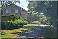
1

Swindon : Footpath
A footpath towards the houses.
Image: © Lewis Clarke
Taken: 14 Jul 2022
0.06 miles
2
Swindon : Footpath
Looking along the path.
Image: © Lewis Clarke
Taken: 14 Jul 2022
0.08 miles
3
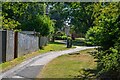
Swindon : Footpath
Looking along the footpath.
Image: © Lewis Clarke
Taken: 14 Jul 2022
0.08 miles
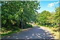
4

Swindon : Footpath
Looking along the footpath.
Image: © Lewis Clarke
Taken: 14 Jul 2022
0.09 miles
5
Swindon : Footpath
A footpath off Freshbrook Way.
Image: © Lewis Clarke
Taken: 14 Jul 2022
0.09 miles
6
Icomb Close, Toothill, Swindon
Viewed from the corner of Harlech Close.
Image: © Jaggery
Taken: 2 Feb 2013
0.10 miles
7
Swindon : Idovers Drive
Looking along the road off Stokesay Drive.
Image: © Lewis Clarke
Taken: 14 Jul 2022
0.12 miles
8
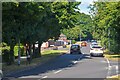
Swindon : Stokesay Drive
Looking along Stokesay Drive.
Image: © Lewis Clarke
Taken: 14 Jul 2022
0.12 miles
9
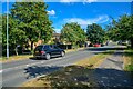
Swindon : Pevensey Way
Heading towards the roundabout.
Image: © Lewis Clarke
Taken: 14 Jul 2022
0.13 miles
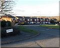
10

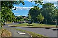
Swindon : Stokesay Drive
Houses on Stokesay Drive.
Image: © Lewis Clarke
Taken: 14 Jul 2022
0.16 miles