1
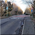
Buses only, Mannington Lane, Swindon
BUSES ONLY is painted on the road surface, but the sign on the left
shows that bicycles (and pedestrians) are also allowed.
Image: © Jaggery
Taken: 2 Feb 2013
0.03 miles
2
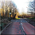
Cycle route crosses Mannington Lane, Swindon
The broken white lines mark the cycle route across the road.
Image: © Jaggery
Taken: 2 Feb 2013
0.04 miles
3
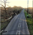
A view east along Tewkesbury Drive, Swindon
Viewed from this http://www.geograph.org.uk/photo/3413487 footbridge, looking past a bus stop,
in the direction of the roundabout at the A3102 junction.
Image: © Jaggery
Taken: 2 Feb 2013
0.08 miles
4
Swindon : Tewkesbury Way B4553
Looking along the road.
Image: © Lewis Clarke
Taken: 14 Jul 2022
0.09 miles
5
Bodiam Drive, Toothill, Swindon
A view east from the corner of Dunwich Drive.
Image: © Jaggery
Taken: 2 Feb 2013
0.11 miles
6
Roundabout on Tewkesbury Way, Swindon
Image: © David Howard
Taken: 26 Oct 2019
0.13 miles
7
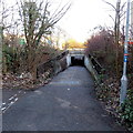
Cycle route underpass, Great Western Way, Swindon
National Cycle Network route 45 passes under Great Western Way
to the north of Mannington roundabout.
Image: © Jaggery
Taken: 2 Feb 2013
0.15 miles
8
Westlea Drive, West Swindon
Showing a playground on the left, and typical housing on the right.
Image: © Vieve Forward
Taken: 30 Dec 2012
0.15 miles
9
Great Western Way approaches Mannington roundabout from the north, Swindon
The B4008 Great Western Way on this side of the roundabout becomes the A3102 Great Western Way on the south side of the roundabout.
Image: © Jaggery
Taken: 2 Feb 2013
0.15 miles
10
Intergraph (west), Delta Business Park, Swindon (2)
Intergraph are a high-tech company who are 'a leading global provider of spatial information management (SIM) software' according to their website. I think that's something to do with geographical information systems. They have two buildings here, one on either side of the road and facing each other.
Image: © Brian Robert Marshall
Taken: 30 Oct 2007
0.15 miles


