IMAGES TAKEN NEAR TO
Stonybeck Close, SWINDON, SN5 7AQ
Introduction
This page details the photographs taken nearby to Stonybeck Close, SN5 7AQ by members of the Geograph project.
The Geograph project started in 2005 with the aim of publishing, organising and preserving representative images for every square kilometre of Great Britain, Ireland and the Isle of Man.

There are currently over 7.5m images from over14,400 individuals and you can help contribute to the project by visiting https://www.geograph.org.uk
Image Map
Images are licensed for reuse under creativecommons.org/licenses/by-sa/2.0
Notes
- Clicking on the map will re-center to the selected point.
- The higher the marker number, the further away the image location is from the centre of the postcode.
Image Listing (19 Images Found)
Images are licensed for reuse under creativecommons.org/licenses/by-sa/2.0
Image
Details
Distance
1

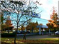
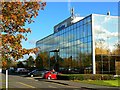
Intergraph (west), Delta Business Park, Swindon (4)
Intergraph are a high-tech company who are 'a leading global provider of spatial information management (SIM) software' according to their website. I think that's something to do with geographical information systems. They have two buildings here, one on either side of the road and facing each other.
Image: © Brian Robert Marshall
Taken: 30 Oct 2007
0.13 miles
2

Intergraph (west), Delta Business Park, Swindon (2)
Intergraph are a high-tech company who are 'a leading global provider of spatial information management (SIM) software' according to their website. I think that's something to do with geographical information systems. They have two buildings here, one on either side of the road and facing each other.
Image: © Brian Robert Marshall
Taken: 30 Oct 2007
0.14 miles
3
Intergraph (west), Delta Business Park, Swindon (1)
Intergraph are a high-tech company who are 'a leading global provider of spatial information management (SIM) software' according to their website. I think that's something to do with geographical information systems. They have two buildings here, one on either side of the road and facing each other.
Image: © Brian Robert Marshall
Taken: 30 Oct 2007
0.15 miles
4
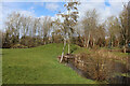
Westlea Park
Small lake in Westlea Park.
Image: © Wayland Smith
Taken: 13 Mar 2021
0.16 miles
5

Intergraph (west), Delta Business Park, Swindon (3)
Intergraph are a high-tech company who are 'a leading global provider of spatial information management (SIM) software' according to their website. I think that's something to do with geographical information systems. They have two buildings here, one on either side of the road and facing each other. The other building can be seen reflected in this one.
Image: © Brian Robert Marshall
Taken: 30 Oct 2007
0.16 miles
6
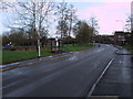
Westlea Drive, West Swindon
Showing a playground on the left, and typical housing on the right.
Image: © Vieve Forward
Taken: 30 Dec 2012
0.16 miles
7
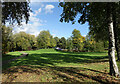
Westlea Park
Trees and lawns and a playground in the midst of all the houses.
Image: © Des Blenkinsopp
Taken: 17 Oct 2022
0.16 miles
8
Intergraph (east), Delta Business Park, Swindon
Intergraph are a high-tech company who are 'a leading global provider of spatial information management (SIM) software' according to their website. I think that's something to do with geographical information systems. They have two buildings here, one on either side of the road and facing each other.
Image: © Brian Robert Marshall
Taken: 30 Oct 2007
0.18 miles
9
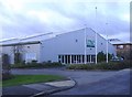
Delta tennis centre
An indoor tennis facility, opened at Westlea in the 1980's
Image: © Roger Cornfoot
Taken: 10 Jan 2007
0.20 miles
10
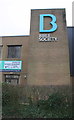
Jut on Mead Way face of Bible Society building
There is an OS benchmark Image at the base of the jut, behind the hedge
Image: © Roger Templeman
Taken: 15 Mar 2016
0.22 miles