1
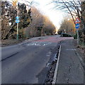
Buses only, Mannington Lane, Swindon
BUSES ONLY is painted on the road surface, but the sign on the left
shows that bicycles (and pedestrians) are also allowed.
Image: © Jaggery
Taken: 2 Feb 2013
0.08 miles
2
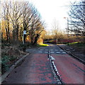
Cycle route crosses Mannington Lane, Swindon
The broken white lines mark the cycle route across the road.
Image: © Jaggery
Taken: 2 Feb 2013
0.09 miles
3
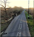
A view east along Tewkesbury Drive, Swindon
Viewed from this http://www.geograph.org.uk/photo/3413487 footbridge, looking past a bus stop,
in the direction of the roundabout at the A3102 junction.
Image: © Jaggery
Taken: 2 Feb 2013
0.10 miles
4
Westlea Drive, West Swindon
Showing a playground on the left, and typical housing on the right.
Image: © Vieve Forward
Taken: 30 Dec 2012
0.10 miles
5
Westlea Park
Small lake in Westlea Park.
Image: © Wayland Smith
Taken: 13 Mar 2021
0.12 miles
6
Westlea Park
Trees and lawns and a playground in the midst of all the houses.
Image: © Des Blenkinsopp
Taken: 17 Oct 2022
0.13 miles
7
Bodiam Drive, Toothill, Swindon
A view east from the corner of Dunwich Drive.
Image: © Jaggery
Taken: 2 Feb 2013
0.13 miles
8
Intergraph (west), Delta Business Park, Swindon (2)
Intergraph are a high-tech company who are 'a leading global provider of spatial information management (SIM) software' according to their website. I think that's something to do with geographical information systems. They have two buildings here, one on either side of the road and facing each other.
Image: © Brian Robert Marshall
Taken: 30 Oct 2007
0.14 miles
9
Tewkesbury Drive footbridge, Swindon
The footbridge over the B4553 Tewkesbury Drive connects
the Toothill district on this side with Westlea on the far side.
Image: © Jaggery
Taken: 2 Feb 2013
0.15 miles
10
Swindon : Tewkesbury Way B4553
Looking along the road.
Image: © Lewis Clarke
Taken: 14 Jul 2022
0.15 miles


