IMAGES TAKEN NEAR TO
Hillyard Close, SWINDON, SN5 6ED
Introduction
This page details the photographs taken nearby to Hillyard Close, SN5 6ED by members of the Geograph project.
The Geograph project started in 2005 with the aim of publishing, organising and preserving representative images for every square kilometre of Great Britain, Ireland and the Isle of Man.

There are currently over 7.5m images from over14,400 individuals and you can help contribute to the project by visiting https://www.geograph.org.uk
Image Map
Images are licensed for reuse under creativecommons.org/licenses/by-sa/2.0
Notes
- Clicking on the map will re-center to the selected point.
- The higher the marker number, the further away the image location is from the centre of the postcode.
Image Listing (5 Images Found)
Images are licensed for reuse under creativecommons.org/licenses/by-sa/2.0
Image
Details
Distance
1
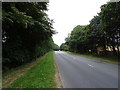
Hook Street, Grange Park, Swindon
Hook Street leads away from the viewpoint to the village of Hook, near Wootton Bassett. The road to the right goes into part of the Grange Park development in West Swindon.
Image: © Brian Robert Marshall
Taken: 9 Apr 2008
0.16 miles
2
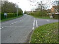
Heading towards the west side of Swindon
Image: © Rob Purvis
Taken: 11 Jun 2013
0.22 miles
3
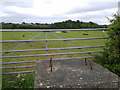
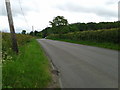
Cows in a field which has the entrance barred with a large concrete block
Image: © Rob Purvis
Taken: 11 Jun 2013
0.23 miles
4
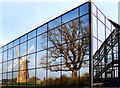
Windmill in the Windows
This windmill was originally at Chiseldon about 10 kms east of here.
It was re-erected as a feature in the middle of the Windmill Hill business park.
Surrounded by glass panelled office buildings it provides some good photo opportunities.
This is from a print. Date Approximate.
Image: © Des Blenkinsopp
Taken: Unknown
0.24 miles