IMAGES TAKEN NEAR TO
Lydford Close, SWINDON, SN5 5UF
Introduction
This page details the photographs taken nearby to Lydford Close, SN5 5UF by members of the Geograph project.
The Geograph project started in 2005 with the aim of publishing, organising and preserving representative images for every square kilometre of Great Britain, Ireland and the Isle of Man.

There are currently over 7.5m images from over14,400 individuals and you can help contribute to the project by visiting https://www.geograph.org.uk
Image Map
Images are licensed for reuse under creativecommons.org/licenses/by-sa/2.0
Notes
- Clicking on the map will re-center to the selected point.
- The higher the marker number, the further away the image location is from the centre of the postcode.
Image Listing (14 Images Found)
Images are licensed for reuse under creativecommons.org/licenses/by-sa/2.0
Image
Details
Distance
2
Minor case of Christmas flooding outside Brookfield Primary School, Swindon
The event seen here on Christmas Day 2013 is not actually 'flooding' but more a large puddle. Not many families will be going through here today!
Image: © Robert Gourley
Taken: 25 Dec 2013
0.08 miles
3
Brook Field primary school, Shaw, West Swindon
The school was closed at the time this image was obtained. Because of an early Easter in 2008 the traditional two week break was deferred until this week and next. The chimney in the background serves an industrial operation in Hillmead.
Image: © Brian Robert Marshall
Taken: 9 Apr 2008
0.17 miles
5
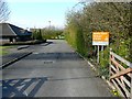
Cartwright Drive, Shaw, West Swindon
Cartwright Drive is a fairly twisty spine road that runs through a residential area. This is a view facing east from the entrance to a local school.
Image: © Brian Robert Marshall
Taken: 9 Apr 2008
0.20 miles
6
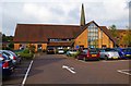
Holy Trinity Church Shaw, Shaw Village Centre, Ramleaze Drive, Shaw, Swindon
This modern local church is part of the West Swindon & Lydiard Tregoze Church Partnership. Each church is multi-denominational (Anglican, Baptist, Methodist, and United Reformed Church).
Image: © P L Chadwick
Taken: 22 Oct 2016
0.20 miles
7
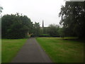
Holy Trinity Church, Shaw
The spire of the Holy Trinity Church, Shaw, can be ceen beyond the trees. Tesco Express also operates in the area, along with the Village Inn.
Image: © Robert Gourley
Taken: 19 Jun 2013
0.22 miles
8
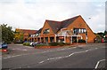
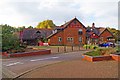
Ramleaze House, Shaw Village Centre, Ramleaze Drive, Shaw, Swindon
The building houses various businesses including Shaw Kebab, on the corner, and a branch of Lloyds Pharmacy.
Image: © P L Chadwick
Taken: 22 Oct 2016
0.22 miles
9
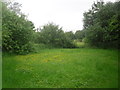
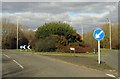
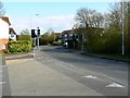
View towards Middleleaze Drive, Swindon
The street light (central right) is for Middleleaze drive. Summer is already here, and the flowers appear to be out!
Image: © Robert Gourley
Taken: 19 Jun 2013
0.22 miles
10
The Village Inn (1), Shaw Village Centre, Ramleaze Drive, Shaw, Swindon
This modern public house is in the centre of one of Swindon's "urban villages". It is owned by Mitchells & Butlers and is one of their "Sizzling Pubs", with an emphasis on food, which is served all day from breaskfast onwards.
Image
Image: © P L Chadwick
Taken: 22 Oct 2016
0.23 miles