IMAGES TAKEN NEAR TO
Ramleaze Drive, SWINDON, SN5 5PZ
Introduction
This page details the photographs taken nearby to Ramleaze Drive, SN5 5PZ by members of the Geograph project.
The Geograph project started in 2005 with the aim of publishing, organising and preserving representative images for every square kilometre of Great Britain, Ireland and the Isle of Man.

There are currently over 7.5m images from over14,400 individuals and you can help contribute to the project by visiting https://www.geograph.org.uk
Image Map
Images are licensed for reuse under creativecommons.org/licenses/by-sa/2.0
Notes
- Clicking on the map will re-center to the selected point.
- The higher the marker number, the further away the image location is from the centre of the postcode.
Image Listing (5 Images Found)
Images are licensed for reuse under creativecommons.org/licenses/by-sa/2.0
Image
Details
Distance
1
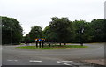
Roundabout on Roughmoor Way, Swindon
Junction with Tewkesbury Way.
Image: © JThomas
Taken: 14 Jul 2019
0.22 miles
2
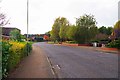
Ramleaze Drive, Shaw Village, Swindon
One of the main roads in the Shaw area.
Image: © P L Chadwick
Taken: 22 Oct 2016
0.23 miles
3
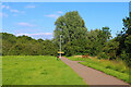
Grange Park
Footpath near Chandos Close.
Image: © Wayland Smith
Taken: 15 Jul 2021
0.24 miles
4
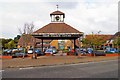
The Clock Tower, Shaw Village Centre, Ramleaze Drive, Shaw, Swindon
This prominent feature is adjacent to the public car park with the local church behind.
Image: © P L Chadwick
Taken: 22 Oct 2016
0.24 miles
5
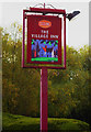
The Village Inn (2) - sign, Shaw Village Centre, Ramleaze Drive, Shaw, Swindon
Located on a post near Ramleaze Drive.
Image
Image: © P L Chadwick
Taken: 22 Oct 2016
0.24 miles