IMAGES TAKEN NEAR TO
Harvester Close, SWINDON, SN5 5GJ
Introduction
This page details the photographs taken nearby to Harvester Close, SN5 5GJ by members of the Geograph project.
The Geograph project started in 2005 with the aim of publishing, organising and preserving representative images for every square kilometre of Great Britain, Ireland and the Isle of Man.

There are currently over 7.5m images from over14,400 individuals and you can help contribute to the project by visiting https://www.geograph.org.uk
Image Map
Images are licensed for reuse under creativecommons.org/licenses/by-sa/2.0
Notes
- Clicking on the map will re-center to the selected point.
- The higher the marker number, the further away the image location is from the centre of the postcode.
Image Listing (5 Images Found)
Images are licensed for reuse under creativecommons.org/licenses/by-sa/2.0
Image
Details
Distance
1
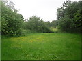
View towards Middleleaze Drive, Swindon
The street light (central right) is for Middleleaze drive. Summer is already here, and the flowers appear to be out!
Image: © Robert Gourley
Taken: 19 Jun 2013
0.16 miles
2
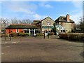
Brookhouse Farm by Middleaze Drive
Brookhouse Farm is a Hungry Horse public house.
Image: © Steve Daniels
Taken: 13 Mar 2023
0.22 miles
5
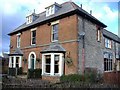
Brook House Farm
Once an isolated farmhouse, in the 1980's, this building was converted into a pub-restaurant, during the rapid western expansion of Swindon. It is now part of the 'Hungry Horse' chain.
Image: © Roger Cornfoot
Taken: 10 Jan 2007
0.24 miles