IMAGES TAKEN NEAR TO
Mustang Way, SWINDON, SN5 5DY
Introduction
This page details the photographs taken nearby to Mustang Way, SN5 5DY by members of the Geograph project.
The Geograph project started in 2005 with the aim of publishing, organising and preserving representative images for every square kilometre of Great Britain, Ireland and the Isle of Man.

There are currently over 7.5m images from over14,400 individuals and you can help contribute to the project by visiting https://www.geograph.org.uk
Image Map
Images are licensed for reuse under creativecommons.org/licenses/by-sa/2.0
Notes
- Clicking on the map will re-center to the selected point.
- The higher the marker number, the further away the image location is from the centre of the postcode.
Image Listing (30 Images Found)
Images are licensed for reuse under creativecommons.org/licenses/by-sa/2.0
Image
Details
Distance
1
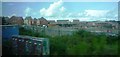
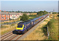
Expansion of housing estate near railway line at Swindon
Housing estate near Elborough Bridge has been expanded south towards the railway line on the outskirts of Swindon. View from westbound train, looking towards Mustang Way.
Image: © Clint Mann
Taken: 11 Aug 2014
0.06 miles
2
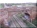
Rail bridge at Moredon
Now superseded by a modern concrete structure, this Victorian structure has been adopted by third-rate graffiti artists.
Image: © Roger Cornfoot
Taken: 15 Jan 2007
0.12 miles
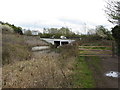
4
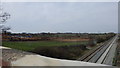
Ridgeway Farm construction site, March 2014
As can be seen above, work is well underway on site clearance for the upcoming Ridgeway Farm development.
Image: © Robert Gourley
Taken: 30 Mar 2014
0.13 miles
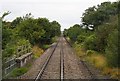
5
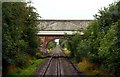
Railway at Moredon Bridge
Main railway line north of Swindon.
Image: © Wayland Smith
Taken: 14 Jul 2018
0.14 miles
6
Purton Road bridge on the former Wilts & Berks Canal
Image: © Gareth James
Taken: 14 Apr 2012
0.17 miles
7
A bridge over a tributary of the River Ray
Image: © Steve Daniels
Taken: 2 Sep 2009
0.18 miles
8
Wilts & Berks Canal (North Wilts Branch) looking south-east from Mouldon Lock
The North Wilts branch formerly connected the main Wilts & Berks Canal with the Thames and Severn Canal, and ran between Swindon and Latton. This is the view south-east along the disused canal from Mouldon Lock, the lowest of the flight of three Moredon Locks.
http://www.wbct.org.uk/branches/swindon/restoration/38 http://www.smithswbc.org.uk/
Image: © Vieve Forward
Taken: 23 Feb 2012
0.18 miles
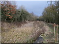
10
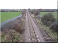
Railway to Gloucester
Running northwest from Swindon. Once a double track main line, the sleepers from the second line remain in place, at this point.
Image: © Roger Cornfoot
Taken: 15 Jan 2007
0.20 miles