IMAGES TAKEN NEAR TO
Cricklade Road, SWINDON, SN5 4GW
Introduction
This page details the photographs taken nearby to Cricklade Road, SN5 4GW by members of the Geograph project.
The Geograph project started in 2005 with the aim of publishing, organising and preserving representative images for every square kilometre of Great Britain, Ireland and the Isle of Man.

There are currently over 7.5m images from over14,400 individuals and you can help contribute to the project by visiting https://www.geograph.org.uk
Image Map
Images are licensed for reuse under creativecommons.org/licenses/by-sa/2.0
Notes
- Clicking on the map will re-center to the selected point.
- The higher the marker number, the further away the image location is from the centre of the postcode.
Image Listing (3 Images Found)
Images are licensed for reuse under creativecommons.org/licenses/by-sa/2.0
Image
Details
Distance
1
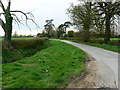
Bentham Lane, Purton Stoke
Bentham Lane serves quite a few farms, houses and cottages most of which can't be seen in this image.
Image: © Brian Robert Marshall
Taken: 5 Apr 2009
0.17 miles
2
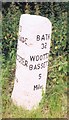
Old Milestone by Cricklade Road, near Pound Farm, Purton parish
Purton column by the UC road, in parish of Purton (North Wiltshire District), Cricklade Road; 140m North of Pound Farm, Widham, 20m North of Mopes Lane junction to landfill, on wide grass verge.
Inscription reads:-
: TO / CRICKLADE / 3 / CIRENCESTER / 10 / Miles : : BATH / 32 / WOOTTON BASSETT / 5 Miles :
Grade II listed.
List Entry Number: 1198327 https://historicengland.org.uk/listing/the-list/list-entry/1198327
Surveyed
Milestone Society National ID: WI_CKWB05
Image: © Milestone Society
Taken: Unknown
0.19 miles
3
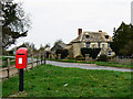
Hurstead Farm, Purton Stoke
The farm sits on the B4553 road to Cricklade. The postbox looks very modern.
Image: © Brian Robert Marshall
Taken: 5 Apr 2009
0.21 miles