IMAGES TAKEN NEAR TO
Marsh Close, SWINDON, SN5 4GJ
Introduction
This page details the photographs taken nearby to Marsh Close, SN5 4GJ by members of the Geograph project.
The Geograph project started in 2005 with the aim of publishing, organising and preserving representative images for every square kilometre of Great Britain, Ireland and the Isle of Man.

There are currently over 7.5m images from over14,400 individuals and you can help contribute to the project by visiting https://www.geograph.org.uk
Image Map
Images are licensed for reuse under creativecommons.org/licenses/by-sa/2.0
Notes
- Clicking on the map will re-center to the selected point.
- The higher the marker number, the further away the image location is from the centre of the postcode.
Image Listing (16 Images Found)
Images are licensed for reuse under creativecommons.org/licenses/by-sa/2.0
Image
Details
Distance
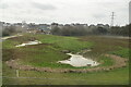
2
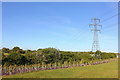
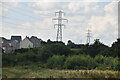
Peatmoor, Swindon
Field and electricity pylon near Peatmoor.
Image: © Wayland Smith
Taken: 19 May 2020
0.11 miles
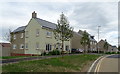
3
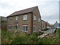
Cowleaze
New housing development off the B4553.
Image: © JThomas
Taken: 11 Jul 2019
0.12 miles
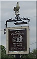
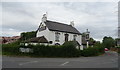
7
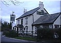
The Foresters Arms
Sitting at the crossroads, Common Platt.
Image: © Roger Cornfoot
Taken: 15 Jan 2007
0.17 miles
9
Casa Paolo, Common Platt
Restaurant, bar and grill.
Image: © JThomas
Taken: 11 Jul 2019
0.19 miles