IMAGES TAKEN NEAR TO
Pavenhill Courtyard, SWINDON, SN5 4FH
Introduction
This page details the photographs taken nearby to Pavenhill Courtyard, SN5 4FH by members of the Geograph project.
The Geograph project started in 2005 with the aim of publishing, organising and preserving representative images for every square kilometre of Great Britain, Ireland and the Isle of Man.

There are currently over 7.5m images from over14,400 individuals and you can help contribute to the project by visiting https://www.geograph.org.uk
Image Map
Images are licensed for reuse under creativecommons.org/licenses/by-sa/2.0
Notes
- Clicking on the map will re-center to the selected point.
- The higher the marker number, the further away the image location is from the centre of the postcode.
Image Listing (9 Images Found)
Images are licensed for reuse under creativecommons.org/licenses/by-sa/2.0
Image
Details
Distance
1
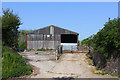
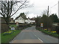
South Pavenhill Farm
Farm building near Purton.
Image: © Wayland Smith
Taken: 25 Apr 2020
0.07 miles
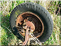
5
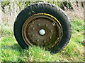
Wheel, near Purton
This is one of a pair attached to a beam axle dating probably to the 1920s.
Image: © Brian Robert Marshall
Taken: 2 Apr 2009
0.19 miles
6
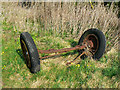
Wheels and axle, near Purton
The wheels are attached to a beam axle, almost certainly from the front of an ancient vehicle. Not easy to identify but probably from the 1920s.
Image: © Brian Robert Marshall
Taken: 2 Apr 2009
0.19 miles
7
Wheel, near Purton
The wheel is attached to what was once the front axle of a vehicle, possibly a truck, dating probably from 1920s. The tyre is pneumatic.
Image: © Brian Robert Marshall
Taken: 2 Apr 2009
0.19 miles