IMAGES TAKEN NEAR TO
Church End, SWINDON, SN5 4ED
Introduction
This page details the photographs taken nearby to Church End, SN5 4ED by members of the Geograph project.
The Geograph project started in 2005 with the aim of publishing, organising and preserving representative images for every square kilometre of Great Britain, Ireland and the Isle of Man.

There are currently over 7.5m images from over14,400 individuals and you can help contribute to the project by visiting https://www.geograph.org.uk
Image Map
Images are licensed for reuse under creativecommons.org/licenses/by-sa/2.0
Notes
- Clicking on the map will re-center to the selected point.
- The higher the marker number, the further away the image location is from the centre of the postcode.
Image Listing (121 Images Found)
Images are licensed for reuse under creativecommons.org/licenses/by-sa/2.0
Image
Details
Distance
1
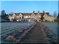
The Pear Tree at Purton
Hotel seen from the lawn on a frosty morning.
Image: © David Martin
Taken: 19 Feb 2013
0.00 miles
3
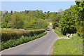
Near Manor Farm
Road south of Purton.
Image: © Wayland Smith
Taken: 25 Apr 2020
0.06 miles
4
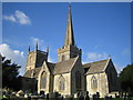
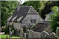
Purton: St Mary's Church
The church is unusual in having two towers, one with a steeple. Nevil Maskelyne, who was the Astronomer Royal for 42 years from 1763 until 1805, is buried in the churchyard.
Image: © Nigel Cox
Taken: 24 Oct 2006
0.09 miles
5
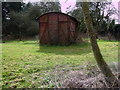
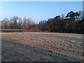
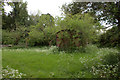
Disused railway carriage, Purton
Standing in a field in Purton, this disused railway goods wagon is being used as a shed or barn.
Image: © Vieve Forward
Taken: 3 Mar 2012
0.10 miles
6
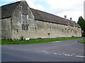
Tithe Barn, Purton
This group of buildings built in the 15th and 16th centuries. They have been converted to homes.
Image: © Maigheach-gheal
Taken: 9 Aug 2009
0.10 miles
7
![Purton houses [3]](https://s2.geograph.org.uk/geophotos/06/35/36/6353626_61c7ec4f_120x120.jpg)
Purton houses [3]
The Butt Hay, number 4 Church End is 17th or 18th century with 20th century additions. Thought to be an extension of a since demolished church hall. Listed, grade II, with details at: https://historicengland.org.uk/listing/the-list/list-entry/1198306
Originally built round the parish church, manor and Tithe barn, the village moved and is now mostly spread out along the Bristol and Oxford coach road.
Image: © Michael Dibb
Taken: 28 Aug 2019
0.11 miles
8
Purton: House bordering St. Mary's Churchyard
Image: © Michael Garlick
Taken: 19 May 2017
0.11 miles
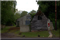
10
Old railway van near Purton
Nature has taken its course since this was last photographed five years ago - see no 2832587.
Image: © Robert Eva
Taken: 13 May 2017
0.12 miles