IMAGES TAKEN NEAR TO
Play Close, SWINDON, SN5 4DP
Introduction
This page details the photographs taken nearby to Play Close, SN5 4DP by members of the Geograph project.
The Geograph project started in 2005 with the aim of publishing, organising and preserving representative images for every square kilometre of Great Britain, Ireland and the Isle of Man.

There are currently over 7.5m images from over14,400 individuals and you can help contribute to the project by visiting https://www.geograph.org.uk
Image Map
Images are licensed for reuse under creativecommons.org/licenses/by-sa/2.0
Notes
- Clicking on the map will re-center to the selected point.
- The higher the marker number, the further away the image location is from the centre of the postcode.
Image Listing (48 Images Found)
Images are licensed for reuse under creativecommons.org/licenses/by-sa/2.0
Image
Details
Distance
1
![Purton buildings [12]](https://s1.geograph.org.uk/geophotos/06/35/68/6356829_c7f8ef7b_120x120.jpg)
Purton buildings [12]
The Methodist church was built as a Wesleyan Chapel in 1892. The Primitive Methodists and Wesleyan Methodists united in 1969 and after extensive modernisation work the church reopened in 1973.
Originally built round the parish church, manor and Tithe barn, the village moved and is now mostly spread out along the Bristol and Oxford coach road.
Image: © Michael Dibb
Taken: 28 Aug 2019
0.02 miles
2
![Purton features [6]](https://s0.geograph.org.uk/geophotos/06/35/68/6356828_fc1173a4_120x120.jpg)
Purton features [6]
A well equipped play area in the appropriately named Play Close.
Originally built round the parish church, manor and Tithe barn, the village moved and is now mostly spread out along the Bristol and Oxford coach road.
Image: © Michael Dibb
Taken: 28 Aug 2019
0.03 miles
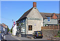
6
![Purton buildings [7]](https://s0.geograph.org.uk/geophotos/06/35/57/6355764_3c32615d_120x120.jpg)
Purton buildings [7]
The wing of The Angel public house on High Street is dated 1704 whilst the extension along Play Close is 19th century. Used as a meeting place by the local magistrates in the 18th and 19th centuries. Listed, grade II, with details at: https://historicengland.org.uk/listing/the-list/list-entry/1283866
Originally built round the parish church, manor and Tithe barn, the village moved and is now mostly spread out along the Bristol and Oxford coach road.
Image: © Michael Dibb
Taken: 28 Aug 2019
0.03 miles
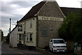
7
![Purton buildings [6]](https://s1.geograph.org.uk/geophotos/06/35/57/6355761_0a2e1f31_120x120.jpg)
Purton buildings [6]
The wing of The Angel public house on High Street is dated 1704 whilst the extension along Play Close is 19th century. Used as a meeting place by the local magistrates in the 18th and 19th centuries. Listed, grade II, with details at: https://historicengland.org.uk/listing/the-list/list-entry/1283866
Originally built round the parish church, manor and Tithe barn, the village moved and is now mostly spread out along the Bristol and Oxford coach road.
Image: © Michael Dibb
Taken: 28 Aug 2019
0.04 miles
8
![Purton features [2]](https://s0.geograph.org.uk/geophotos/06/35/68/6356816_999b0dd5_120x120.jpg)
Purton features [2]
This fine late 18th or early 19th century milestone gives the distance to Bath as 31 miles. Listed, grade II, with details at: https://historicengland.org.uk/listing/the-list/list-entry/1356024 See Image for the milestone in context.
Originally built round the parish church, manor and Tithe barn, the village moved and is now mostly spread out along the Bristol and Oxford coach road.
Image: © Michael Dibb
Taken: 28 Aug 2019
0.04 miles
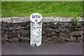
9
![Purton features [3]](https://s1.geograph.org.uk/geophotos/06/35/68/6356817_c1d998ad_120x120.jpg)
Purton features [3]
This fine late 18th or early 19th century milestone gives the distance to Bath as 31 miles. Listed, grade II, with details at: https://historicengland.org.uk/listing/the-list/list-entry/1356024 See Image for a close view of the milestone.
Originally built round the parish church, manor and Tithe barn, the village moved and is now mostly spread out along the Bristol and Oxford coach road.
Image: © Michael Dibb
Taken: 28 Aug 2019
0.04 miles
10
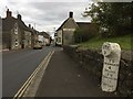
Purton Milestone
Old milestone by the Angel Inn, marking old coach route to Bath? Other side of stone notes distance to Wootton Bassett.
Image: © Jeremy Newcombe
Taken: 6 Nov 2016
0.04 miles