IMAGES TAKEN NEAR TO
High Street, SWINDON, SN5 4AA
Introduction
This page details the photographs taken nearby to High Street, SN5 4AA by members of the Geograph project.
The Geograph project started in 2005 with the aim of publishing, organising and preserving representative images for every square kilometre of Great Britain, Ireland and the Isle of Man.

There are currently over 7.5m images from over14,400 individuals and you can help contribute to the project by visiting https://www.geograph.org.uk
Image Map
Images are licensed for reuse under creativecommons.org/licenses/by-sa/2.0
Notes
- Clicking on the map will re-center to the selected point.
- The higher the marker number, the further away the image location is from the centre of the postcode.
Image Listing (50 Images Found)
Images are licensed for reuse under creativecommons.org/licenses/by-sa/2.0
Image
Details
Distance
1
![Purton buildings [8]](https://s1.geograph.org.uk/geophotos/06/35/57/6355769_5be513e5_120x120.jpg)
Purton buildings [8]
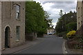
Number 7 High Street, built in 1673, is the former Maltsters public house. The roof was raised in brick in the early 20th century to provide attic accommodation. The building became a restaurant before it closed in 1994 and is now a private dwelling. Listed, grade II, with details at: https://historicengland.org.uk/listing/the-list/list-entry/1023176
Originally built round the parish church, manor and Tithe barn, the village moved and is now mostly spread out along the Bristol and Oxford coach road.
Image: © Michael Dibb
Taken: 28 Aug 2019
0.01 miles
2
![Purton buildings [6]](https://s1.geograph.org.uk/geophotos/06/35/57/6355761_0a2e1f31_120x120.jpg)
Purton buildings [6]
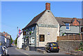
The wing of The Angel public house on High Street is dated 1704 whilst the extension along Play Close is 19th century. Used as a meeting place by the local magistrates in the 18th and 19th centuries. Listed, grade II, with details at: https://historicengland.org.uk/listing/the-list/list-entry/1283866
Originally built round the parish church, manor and Tithe barn, the village moved and is now mostly spread out along the Bristol and Oxford coach road.
Image: © Michael Dibb
Taken: 28 Aug 2019
0.02 miles
5
![Purton buildings [7]](https://s0.geograph.org.uk/geophotos/06/35/57/6355764_3c32615d_120x120.jpg)
Purton buildings [7]
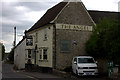
The wing of The Angel public house on High Street is dated 1704 whilst the extension along Play Close is 19th century. Used as a meeting place by the local magistrates in the 18th and 19th centuries. Listed, grade II, with details at: https://historicengland.org.uk/listing/the-list/list-entry/1283866
Originally built round the parish church, manor and Tithe barn, the village moved and is now mostly spread out along the Bristol and Oxford coach road.
Image: © Michael Dibb
Taken: 28 Aug 2019
0.03 miles
8
![Purton features [3]](https://s1.geograph.org.uk/geophotos/06/35/68/6356817_c1d998ad_120x120.jpg)
Purton features [3]
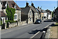
This fine late 18th or early 19th century milestone gives the distance to Bath as 31 miles. Listed, grade II, with details at: https://historicengland.org.uk/listing/the-list/list-entry/1356024 See Image for a close view of the milestone.
Originally built round the parish church, manor and Tithe barn, the village moved and is now mostly spread out along the Bristol and Oxford coach road.
Image: © Michael Dibb
Taken: 28 Aug 2019
0.04 miles
9
![Purton features [2]](https://s0.geograph.org.uk/geophotos/06/35/68/6356816_999b0dd5_120x120.jpg)
Purton features [2]
This fine late 18th or early 19th century milestone gives the distance to Bath as 31 miles. Listed, grade II, with details at: https://historicengland.org.uk/listing/the-list/list-entry/1356024 See Image for the milestone in context.
Originally built round the parish church, manor and Tithe barn, the village moved and is now mostly spread out along the Bristol and Oxford coach road.
Image: © Michael Dibb
Taken: 28 Aug 2019
0.04 miles
10
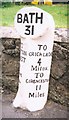
Old Milestone by High Street, Purton
Purton roundel column by the UC road, in parish of Purton (North Wiltshire District), High Street; opposite No. 15, West of "The Angel" PH, in tarmac footpath, backing onto stone retaining wall of car park.
Inscription reads:-
: TO / WOOTTON / BASSETT / 4 / Miles : : BATH / 31 : : TO / CRICKLADE / 4 / Miles / TO / CIRENCESTER / 11 / Miles
Grade II listed.
List Entry Number: 1356024 https://historicengland.org.uk/listing/the-list/list-entry/1356024
Surveyed
Milestone Society National ID: WI_ckwb04
Image: © Milestone Society
Taken: Unknown
0.04 miles