IMAGES TAKEN NEAR TO
Braydon, SWINDON, SN5 0AQ
Introduction
This page details the photographs taken nearby to SN5 0AQ by members of the Geograph project.
The Geograph project started in 2005 with the aim of publishing, organising and preserving representative images for every square kilometre of Great Britain, Ireland and the Isle of Man.

There are currently over 7.5m images from over14,400 individuals and you can help contribute to the project by visiting https://www.geograph.org.uk
Image Map
Images are licensed for reuse under creativecommons.org/licenses/by-sa/2.0
Notes
- Clicking on the map will re-center to the selected point.
- The higher the marker number, the further away the image location is from the centre of the postcode.
Image Listing (6 Images Found)
Images are licensed for reuse under creativecommons.org/licenses/by-sa/2.0
Image
Details
Distance
1
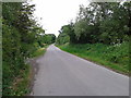
The road past Park Farm, near Callow Hill
The farm is hidden by the trees and bushes on the left.
Image: © Brian Robert Marshall
Taken: 24 Mar 2009
0.05 miles
3
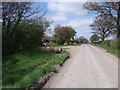
Road past Park Farm, Braydon
The road past Park Farm, showing a farm trailer and an old metal roller. This organic farm is advertising free-range eggs for sale by the roadside. Two cyclists have just ridden by on this well-frequented cycle route, which is part of the Wiltshire Cycleway. http://www.wiltshire.gov.uk/leisureandrecreation/walkingandcycling/wiltshirecycleway.htm
Image: © Vieve Forward
Taken: 18 Apr 2014
0.06 miles
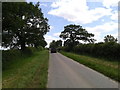
4
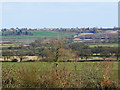
View to Purton from near Callow Hill
The large Wiltshire village of Purton is on top of a hill on the far side of a valley carrying a tributary of the River Key. The high voltage power lines are about a kilometre away.
Image: © Brian Robert Marshall
Taken: 24 Mar 2009
0.11 miles
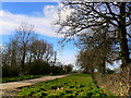
5
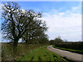
Minor road east of Queen Street
The road runs between two large areas of woodland, Somerford Common to the west and Webb's Wood to the south.
Image: © Brian Robert Marshall
Taken: 24 Mar 2009
0.11 miles