IMAGES TAKEN NEAR TO
Braydon, SWINDON, SN5 0AN
Introduction
This page details the photographs taken nearby to SN5 0AN by members of the Geograph project.
The Geograph project started in 2005 with the aim of publishing, organising and preserving representative images for every square kilometre of Great Britain, Ireland and the Isle of Man.

There are currently over 7.5m images from over14,400 individuals and you can help contribute to the project by visiting https://www.geograph.org.uk
Image Map
Images are licensed for reuse under creativecommons.org/licenses/by-sa/2.0
Notes
- Clicking on the map will re-center to the selected point.
- The higher the marker number, the further away the image location is from the centre of the postcode.
Image Listing (3 Images Found)
Images are licensed for reuse under creativecommons.org/licenses/by-sa/2.0
Image
Details
Distance
1
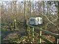
Private caravan site
A 'vintage' caravan sits near the path, through Flaxlands wood.
Image: © Roger Cornfoot
Taken: 7 Feb 2007
0.12 miles
2
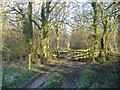
Flaxlands Wood
Looking east, along the public right of way.
Image: © Roger Cornfoot
Taken: 7 Feb 2007
0.13 miles
3
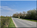
Blaydon Road
Power lines crossing Flaxlands Wood.
Image: © Wayland Smith
Taken: 11 Apr 2020
0.16 miles