IMAGES TAKEN NEAR TO
Costow, SWINDON, SN4 9QN
Introduction
This page details the photographs taken nearby to SN4 9QN by members of the Geograph project.
The Geograph project started in 2005 with the aim of publishing, organising and preserving representative images for every square kilometre of Great Britain, Ireland and the Isle of Man.

There are currently over 7.5m images from over14,400 individuals and you can help contribute to the project by visiting https://www.geograph.org.uk
Image Map
Images are licensed for reuse under creativecommons.org/licenses/by-sa/2.0
Notes
- Clicking on the map will re-center to the selected point.
- The higher the marker number, the further away the image location is from the centre of the postcode.
Image Listing (4 Images Found)
Images are licensed for reuse under creativecommons.org/licenses/by-sa/2.0
Image
Details
Distance
1
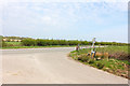
Costow
Junction of Costow and Wharf Road.
Image: © Wayland Smith
Taken: 12 Apr 2020
0.09 miles
3
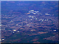
Swindon from the air
Looking over the M4, part of Wroughton can be seen to the lower right.
Image: © Thomas Nugent
Taken: 11 Oct 2010
0.16 miles
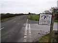
4
Wharf Road to Wroughton
Wharf Road (B4005) runs from Junction 16 on the M4 to the centre of Wroughton.
Image: © Steve Daniels
Taken: 9 Feb 2014
0.20 miles