IMAGES TAKEN NEAR TO
Red Barn, SWINDON, SN4 9LT
Introduction
This page details the photographs taken nearby to Red Barn, SN4 9LT by members of the Geograph project.
The Geograph project started in 2005 with the aim of publishing, organising and preserving representative images for every square kilometre of Great Britain, Ireland and the Isle of Man.

There are currently over 7.5m images from over14,400 individuals and you can help contribute to the project by visiting https://www.geograph.org.uk
Image Map
Images are licensed for reuse under creativecommons.org/licenses/by-sa/2.0
Notes
- Clicking on the map will re-center to the selected point.
- The higher the marker number, the further away the image location is from the centre of the postcode.
Image Listing (27 Images Found)
Images are licensed for reuse under creativecommons.org/licenses/by-sa/2.0
Image
Details
Distance
1
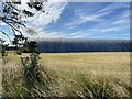
The road to Avebury
The A4361 road having climbed the scarp slope at Wroughton heads towards Avebury. The road on the left leads to Wroughton Airfield
Image: © Michael Dibb
Taken: 5 Aug 2016
0.02 miles
2
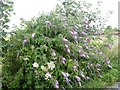
Buddleia davidii
More commonly known as the butterfly bush. Seen opposite the entrance to Wroughton Airfield.
Image: © Michael Dibb
Taken: 5 Aug 2016
0.03 miles
3
![Wroughton Airfield [1]](https://s2.geograph.org.uk/geophotos/05/06/41/5064118_f14b3b62_120x120.jpg)
Wroughton Airfield [1]
The airfield opened in 1940 and the 545 acre site was acquired by the Science Museum in 1979. It is used for large object storage, there are many exhibits such as cars, trains, planes, and hovercraft. The Museum's library is also on the site. This is the entrance to the site, just off the A4361 road.
Image: © Michael Dibb
Taken: 5 Aug 2016
0.05 miles
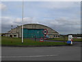
4
![Wroughton Airfield [3]](https://s3.geograph.org.uk/geophotos/05/06/41/5064191_dfb955da_120x120.jpg)
Wroughton Airfield [3]
The airfield opened in 1940 and the 545 acre site was acquired by the Science Museum in 1979. It is used for large object storage, there are many exhibits such as cars, trains, planes, and hovercraft. The Museum's library is also on the site. This is one of the hangars used for storage.
Image: © Michael Dibb
Taken: 5 Aug 2016
0.06 miles
5
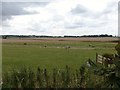
Ponies in the field
Seen from the entrance to Wroughton Airfield. Quidhampton Wood on the skyline.
Image: © Michael Dibb
Taken: 5 Aug 2016
0.06 miles
6
Science Museum at Wroughton
The Science Museum at Wroughton is a Second World War maintenance airfield in Wiltshire and has been occupied by the Science Museum since the 1970s. Six original aircraft hangars house items from the science, engineering, transport and agricultural reserve collections as there is only room for 8% of exhibits in London's Science Museum at any one time.
Image: © Eirian Evans
Taken: 16 Feb 2011
0.07 miles
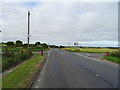
8
The way to the airfield
From the A4361, this road leads to Wroughton Airfield.
Image: © Michael Dibb
Taken: 5 Aug 2016
0.08 miles
9
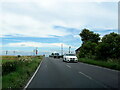
The A4361 north, turn right for Science Museum Library and Store
Image: © Roy Hughes
Taken: 14 Jul 2024
0.09 miles
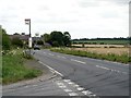
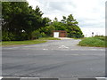
10
Crossroads on the A4361
Turn left for the Science Museum.
Image: © JThomas
Taken: 13 Jul 2019
0.09 miles