IMAGES TAKEN NEAR TO
Wharf Road, SWINDON, SN4 9LE
Introduction
This page details the photographs taken nearby to Wharf Road, SN4 9LE by members of the Geograph project.
The Geograph project started in 2005 with the aim of publishing, organising and preserving representative images for every square kilometre of Great Britain, Ireland and the Isle of Man.

There are currently over 7.5m images from over14,400 individuals and you can help contribute to the project by visiting https://www.geograph.org.uk
Image Map
Images are licensed for reuse under creativecommons.org/licenses/by-sa/2.0
Notes
- Clicking on the map will re-center to the selected point.
- The higher the marker number, the further away the image location is from the centre of the postcode.
Image Listing (48 Images Found)
Images are licensed for reuse under creativecommons.org/licenses/by-sa/2.0
Image
Details
Distance
1
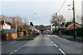
Wharf Road in Wroughton
Wharf Road (B4005) runs from Junction 16 on the M4 to the centre of Wroughton.
Image: © Steve Daniels
Taken: 9 Feb 2014
0.02 miles
2
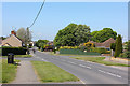
Wharf Road
Junction of Wharf Road and Kerr's Way.
Image: © Wayland Smith
Taken: 26 Apr 2020
0.10 miles
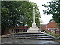
3
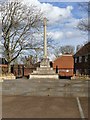
War memorial
Wroughton war memorial is a tall Portland stone cross, dedicated in August 1924 and carries the names of 66 who died in WWI and 26 who died in WWII. The memorial was moved in 1975 from an island in the A4361 road outside the Three Tuns public house Image to its present site. Listed, grade II, with details at: https://historicengland.org.uk/listing/the-list/list-entry/1427672
The large village of Wroughton lies 2 miles south of Swindon at the foot of the Marlborough Downs escarpment. Two headstreams of the River Ray flow from the downs and meet in the village to run north as Wroughton Stream. There is much evidence of settlement and intensive farming of the area in the Roman period. Originally an agricultural village, most workers now commute into Swindon.
Image: © Michael Dibb
Taken: 11 Mar 2020
0.11 miles
4
![Wroughton houses [22]](https://s0.geograph.org.uk/geophotos/06/42/28/6422888_3a3abe9b_120x120.jpg)
Wroughton houses [22]
This substantial, detached house is at number 76 High Street and has some very fine masonry detailing.
The large village of Wroughton lies 2 miles south of Swindon at the foot of the Marlborough Downs escarpment. Two headstreams of the River Ray flow from the downs and meet in the village to run north as Wroughton Stream. There is much evidence of settlement and intensive farming of the area in the Roman period. Originally an agricultural village, most workers now commute into Swindon.
Image: © Michael Dibb
Taken: 11 Mar 2020
0.11 miles
5
![Wroughton houses [24]](https://s2.geograph.org.uk/geophotos/06/42/29/6422902_281a008d_120x120.jpg)
Wroughton houses [24]
Number 20 High Street was an 18th century cottage altered in the early 19th century into a thatched house. Listed, grade II, with details at: https://historicengland.org.uk/listing/the-list/list-entry/1355921
The large village of Wroughton lies 2 miles south of Swindon at the foot of the Marlborough Downs escarpment. Two headstreams of the River Ray flow from the downs and meet in the village to run north as Wroughton Stream. There is much evidence of settlement and intensive farming of the area in the Roman period. Originally an agricultural village, most workers now commute into Swindon.
Image: © Michael Dibb
Taken: 11 Mar 2020
0.11 miles
6
![Wroughton buildings [14]](https://s3.geograph.org.uk/geophotos/06/42/28/6422891_8774b5db_120x120.jpg)
Wroughton buildings [14]
The White Hart, in High Street, is 18th century with later alterations and additions. Listed, grade II, with details at: https://historicengland.org.uk/listing/the-list/list-entry/1023443
The large village of Wroughton lies 2 miles south of Swindon at the foot of the Marlborough Downs escarpment. Two headstreams of the River Ray flow from the downs and meet in the village to run north as Wroughton Stream. There is much evidence of settlement and intensive farming of the area in the Roman period. Originally an agricultural village, most workers now commute into Swindon.
Image: © Michael Dibb
Taken: 11 Mar 2020
0.12 miles
7
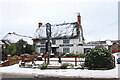
The White Hart
Public House in Wroughton.
Image: © Wayland Smith
Taken: 24 Jan 2021
0.12 miles
8
![Wroughton buildings [13]](https://s3.geograph.org.uk/geophotos/06/42/23/6422359_ceae6ef4_120x120.jpg)
Wroughton buildings [13]
This rather odd building is on the corner of High Street and Wharf Road. The building houses, amongst others, The Great Western Fryer, a fish and chip shop.
The large village of Wroughton lies 2 miles south of Swindon at the foot of the Marlborough Downs escarpment. Two headstreams of the River Ray flow from the downs and meet in the village to run north as Wroughton Stream. There is much evidence of settlement and intensive farming of the area in the Roman period. Originally an agricultural village, most workers now commute into Swindon.
Image: © Michael Dibb
Taken: 11 Mar 2020
0.13 miles
9
![Wroughton buildings [12]](https://s1.geograph.org.uk/geophotos/06/42/28/6422893_544d3b5e_120x120.jpg)
Wroughton buildings [12]
The Carters Rest in High Street specialises in real ale.
The large village of Wroughton lies 2 miles south of Swindon at the foot of the Marlborough Downs escarpment. Two headstreams of the River Ray flow from the downs and meet in the village to run north as Wroughton Stream. There is much evidence of settlement and intensive farming of the area in the Roman period. Originally an agricultural village, most workers now commute into Swindon.
Image: © Michael Dibb
Taken: 11 Mar 2020
0.13 miles
10
War Memorial, Wroughton
Tucked away in front of the library on Wharf Road, the recently restored Wroughton War Memorial looked very impressive even in the driving rain.
Image: © Dave Skinner
Taken: 7 Aug 2010
0.13 miles