
IMAGES TAKEN NEAR TO
Manor Close, SWINDON, SN4 9JN
Introduction
This page details the photographs taken nearby to Manor Close, SN4 9JN by members of the Geograph project.
The Geograph project started in 2005 with the aim of publishing, organising and preserving representative images for every square kilometre of Great Britain, Ireland and the Isle of Man.

There are currently over 7.5m images from over14,400 individuals and you can help contribute to the project by visiting https://www.geograph.org.uk
Image Map
Images are licensed for reuse under creativecommons.org/licenses/by-sa/2.0
Notes
- Clicking on the map will re-center to the selected point.
- The higher the marker number, the further away the image location is from the centre of the postcode.
Image Listing (106 Images Found)
Images are licensed for reuse under creativecommons.org/licenses/by-sa/2.0
Image
Details
Distance
1
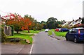
Priors Hill, Wroughton
Further on the road climbs steeply and becomes very narrow. It gives access to the downs and, much further on, to the ancient trackway known as the Ridgeway, which is now a national trail. On the left is an electricity substation.
Image
Image: © P L Chadwick
Taken: 22 Oct 2016
0.06 miles
2
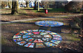
Mosaics on the Green
Some colourful artwork in the small riverside park in the centre of the village.
Image: © Des Blenkinsopp
Taken: 19 Jan 2023
0.07 miles
3
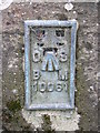
OS flush bracket, Parish church hall, Wroughton
This is Ordnance Survey flush bracket number 10061 http://www.bench-marks.org.uk/bm2586 dating from the days before the second world war when the entire mainland of Britain was comprehensively surveyed and mapped. Even though these flush brackets are now largely if not completely redundant, their legacy lives on in the OSGB36 map reference system still in use to this day. The building to which it is attached can be seen here Image
Image: © Brian Robert Marshall
Taken: 6 Sep 2010
0.07 miles
4
![Wroughton buildings [3]](https://s2.geograph.org.uk/geophotos/05/06/63/5066354_6efd13b3_120x120.jpg)
Wroughton buildings [3]
This church hall in Prior's Hill belongs to the church of St John the Baptist and St Helen. The church is located on the edge of the village at the top of Church Hill.
The large village of Wroughton lies 2 miles south of Swindon at the foot of the Marlborough Downs escarpment. Two headstreams of the River Ray flow from the downs and meet in the village to run north as Wroughton Stream. There is much evidence of settlement and intensive farming of the area in the Roman period. Originally an agricultural village, most workers now commute into Swindon.
Image: © Michael Dibb
Taken: 5 Aug 2016
0.07 miles
5
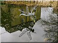
Dragonfly sculpture, Moat Pond, Wroughton
The pond is immediately east of the early 19th century 'Fairwater House' Image The sculpture was constructed by the senior groundsman of Wroughton Parish Council in early 2014. Sadly, it gets vandalized from time to time.
Image: © Brian Robert Marshall
Taken: 9 Apr 2021
0.07 miles
6
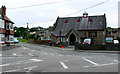
Parish church hall, Wroughton
The church hall is also the Church of St John the Baptist and St Helen. Services are held on Sundays and for the working week it also serves as a day nursery. The hall is available for hire. More information here http://farm5.static.flickr.com/4150/4970289823_f257e192f0_o.jpg The building has an Ordnance Survey flush bracket attached low down on the north-west corner of the front main wall Image
Image: © Brian Robert Marshall
Taken: 6 Sep 2010
0.07 miles
7
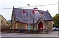
Parish Church Hall, Priors Hill, Wroughton
The church hall is some way from the church itself, which is on the edge of the village. The church hall is used by a nursery and available for hire for functions. Currently one church service a week is held in the hall at 4pm on Sundays.
Image: © P L Chadwick
Taken: 22 Oct 2016
0.07 miles
8
![Wroughton features [12]](https://s0.geograph.org.uk/geophotos/06/42/17/6421712_017eff86_120x120.jpg)
Wroughton features [12]
A fine dragonfly sculpture in the pond.
The large village of Wroughton lies 2 miles south of Swindon at the foot of the Marlborough Downs escarpment. Two headstreams of the River Ray flow from the downs and meet in the village to run north as Wroughton Stream. There is much evidence of settlement and intensive farming of the area in the Roman period. Originally an agricultural village, most workers now commute into Swindon.
Image: © Michael Dibb
Taken: 11 Mar 2020
0.07 miles
9
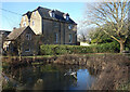
Wroughton Village Pond
Featuring a metal dragonfly sculpture.
Image: © Des Blenkinsopp
Taken: 19 Jan 2023
0.07 miles
10
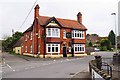
Brown Jack (1), 1 Priors Hill, Wroughton
This used to be an Ushers of Trowbridge Wiltshire public house, but they went out of business in 2000. Currently it is owned by GRS Pub Investments. According to the WhatPub website of the Campaign for Real Ale, this is an "Attractive Edwardian red brick pub dating from 1902. This is a basic drinkers' local which is involved in numerous activities from being home to many and varied teams. The pub also has a skittle alley." It is nice that it has survived, when perhaps surprisingly other local ones such as The Three Tuns and The Swan have not.
Image
Image
Image
Image: © P L Chadwick
Taken: 22 Oct 2016
0.08 miles