IMAGES TAKEN NEAR TO
Clevedon Gardens, SN4 9EZ
Introduction
This page details the photographs taken nearby to Clevedon Gardens, SN4 9EZ by members of the Geograph project.
The Geograph project started in 2005 with the aim of publishing, organising and preserving representative images for every square kilometre of Great Britain, Ireland and the Isle of Man.

There are currently over 7.5m images from over14,400 individuals and you can help contribute to the project by visiting https://www.geograph.org.uk
Image Map
Images are licensed for reuse under creativecommons.org/licenses/by-sa/2.0
Notes
- Clicking on the map will re-center to the selected point.
- The higher the marker number, the further away the image location is from the centre of the postcode.
Image Listing (31 Images Found)
Images are licensed for reuse under creativecommons.org/licenses/by-sa/2.0
Image
Details
Distance
1
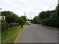
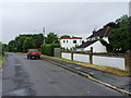
Fairly new houses, Woodland View, Wroughton
There are only a few houses (and a pub) in Woodland View and they are mostly set back from the road. These modern houses are quite close to the road and may occupy the site of what was once a toll house. In the days before the M4 opened in the early 1970s Woodland View was part of Croft Road, the main route south from Swindon towards Avebury and Devizes. The construction of the motorway provided the opportunity to divert the main road, widening it and removing a bend. The old stretch of Croft Road is now in two cul de sacs either side of the motorway of which this is the southern section. The junction of Woodland View with the original main road is just beyond the tree in the background.
Image: © Brian Robert Marshall
Taken: 13 Jul 2010
0.06 miles
2
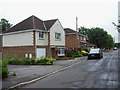
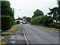
House in Woodland View, Wroughton
The property just to the right of centre is relatively unusual locally in having a flat roof. That feature is uncommon largely because they do need regular maintenance to stop them leaking in the rather damp British climate. In the days before the M4 opened in the early 1970s Woodland View was part of Croft Road, the main route south from Swindon towards Avebury and Devizes. The construction of the motorway provided the opportunity to divert the main road, widening it and removing a bend. The old stretch of Croft Road is now in two cul de sacs either side of the motorway of which this is the southern section. The motorway is about 90 metres away in the direction of view hidden from sight in a cutting.
Image: © Brian Robert Marshall
Taken: 13 Jul 2010
0.07 miles
3
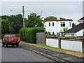
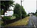
Woodland View, Wroughton (2)
In the days before the M4 opened in the early 1970s Woodland View was part of Croft Road, the main route south from Swindon towards Avebury and Devizes. The construction of the motorway provided the opportunity to divert the main road, widening it and removing a bend. The old stretch of Croft Road is now in two cul de sacs either side of the motorway of which this is the southern section. The motorway is about 90 metres away in the direction of view hidden from sight in a cutting. The road terminated at the local pub http://www.geograph.org.uk/photo/1959796 The Google Streetview car missed this stretch of road.
Image: © Brian Robert Marshall
Taken: 13 Jul 2010
0.07 miles
4
Woodland View, Wroughton (1)
In the days before the M4 opened in the early 1970s Woodland View was part of Croft Road, the main route south from Swindon towards Avebury and Devizes. The construction of the motorway provided the opportunity to divert the main road, widening it and removing a bend. The old stretch of Croft Road is now in two cul de sacs either side of the motorway of which this is the southern section. The view direction is towards the junction of Woodland View with the original main road. This is one of the few roads in the area that weren't photographed by the Google Streetview car.
Image: © Brian Robert Marshall
Taken: 13 Jul 2010
0.07 miles
5
Woodland View, Wroughton (3)
This image provides another look at the unusual flat-roofed house seen here http://www.geograph.org.uk/photo/1959884 In the days before the M4 opened in the early 1970s Woodland View was part of Croft Road, the main route south from Swindon towards Avebury and Devizes. The construction of the motorway provided the opportunity to divert the main road, widening it and removing a bend. The old stretch of Croft Road is now in two cul de sacs either side of the motorway of which this is the southern section. The Google Streetview car didn't trouble to photograph this stretch of road.
Image: © Brian Robert Marshall
Taken: 13 Jul 2010
0.07 miles
6
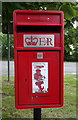
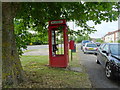
Elizabeth II postbox on Woodland View, North Wroughton
Postbox No. SN4 21.
Image: © JThomas
Taken: 13 Jul 2019
0.08 miles
7
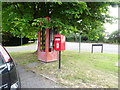
Elizabeth II postbox and telephone box on Woodland View, North Wroughton
Postbox No. SN4 21.
K8 telephone box (in poor condition) is a rare survivor.
Image: © JThomas
Taken: 13 Jul 2019
0.08 miles
8
Elizabeth II postbox and telephone box on Woodland View, North Wroughton
Postbox No. SN4 21.
K8 telephone box (in poor condition) is a rare survivor.
Image: © JThomas
Taken: 13 Jul 2019
0.08 miles