IMAGES TAKEN NEAR TO
Inverary Road, SWINDON, SN4 9DJ
Introduction
This page details the photographs taken nearby to Inverary Road, SN4 9DJ by members of the Geograph project.
The Geograph project started in 2005 with the aim of publishing, organising and preserving representative images for every square kilometre of Great Britain, Ireland and the Isle of Man.

There are currently over 7.5m images from over14,400 individuals and you can help contribute to the project by visiting https://www.geograph.org.uk
Image Map
Images are licensed for reuse under creativecommons.org/licenses/by-sa/2.0
Notes
- Clicking on the map will re-center to the selected point.
- The higher the marker number, the further away the image location is from the centre of the postcode.
Image Listing (8 Images Found)
Images are licensed for reuse under creativecommons.org/licenses/by-sa/2.0
Image
Details
Distance
1
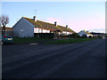
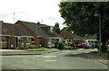
Bungalows, Inverary Road, Wroughton
Bungalows, probably originally council housing stock.
Image: © Vieve Forward
Taken: 1 Jan 2013
0.02 miles
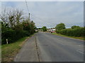
2
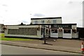
Ridgeway School, Inverary Road, Wroughton
Inverary Road is the road leading away from the viewpoint. The school is on the right. Generally reckoned to be a good school.
Image: © Brian Robert Marshall
Taken: 20 Jan 2007
0.02 miles
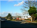
5
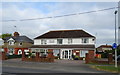
The Iron Horse on Kerrs Way
The Iron Horse is a former Morrells pub that was acquired from Whitbread as a result of the Monopolies and Mergers Commission report in 1989.
Image: © Steve Daniels
Taken: 25 Jun 2014
0.18 miles
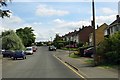
7
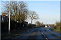
Moormead Road in Wroughton
Looking towards Swindon Road.
Image: © Steve Daniels
Taken: 9 Feb 2014
0.24 miles