IMAGES TAKEN NEAR TO
Moormead Road, SWINDON, SN4 9BX
Introduction
This page details the photographs taken nearby to Moormead Road, SN4 9BX by members of the Geograph project.
The Geograph project started in 2005 with the aim of publishing, organising and preserving representative images for every square kilometre of Great Britain, Ireland and the Isle of Man.

There are currently over 7.5m images from over14,400 individuals and you can help contribute to the project by visiting https://www.geograph.org.uk
Image Map
Images are licensed for reuse under creativecommons.org/licenses/by-sa/2.0
Notes
- Clicking on the map will re-center to the selected point.
- The higher the marker number, the further away the image location is from the centre of the postcode.
Image Listing (65 Images Found)
Images are licensed for reuse under creativecommons.org/licenses/by-sa/2.0
Image
Details
Distance
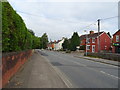
1
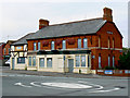
The Three Tuns, Devizes Road, Wroughton
Yet another pub closure is recorded here. The pub is owned by Arkell's brewery Image The erstwhile landlords took over the pub as recently as December 2009. No explanation has been given for their departure and the future of the pub is uncertain. According to a director:
“It is with regret that we have had to close the Three Tuns at Wroughton following the departure of the landlords. “As we do not have a landlord in a position to take over the pub we have boarded it up and have yet to make a firm decision about its future. It is possible that it will not be open again in the short term.” (source swindonadvertiser.co.uk)
The brewery bought the pub as far back as 1889 when it was already a substantial property, with "brewhouse, stables, coach house, shed, piggeries, other out-buildings, yard, garden, half an acre of orchards and meadow land, known as Home Close". Local legend has it that a local, one Dickie Tarrant, would take his horse into the pub with him. The restricted size inside meant the horse had to leave the bar backwards. (source swindonadvertiser.co.uk who probably got it from the Arkells website)
Commenting on the closure a local parish councillor has been quoted as saying:
“I don’t think people will be too sad about it. We’ve got plenty of pubs in the village.” (source swindonadvertiser.co.uk)
Image: © Brian Robert Marshall
Taken: 6 Sep 2010
0.04 miles
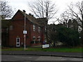
2
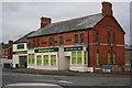
"my Local" convenience store, Wroughton
An ex Morrisons Local store. The 140 Morrison's convenience stores were sold in September 2015 after the chain had made a trading loss on them for a couple of years. This is the rebranded result.
The premises were previously Arkell's "The Three Tuns" which closed in 2010, see Image and Image
The name of the pub can be seen in the brickwork on the gable end. The front has Kingsdown Ales & Porter in the three brick recessed panels.
I can remember the landlord in the late 60s and early 70s, Eddie Bye, having a noisy parrot in the bar; so I used to use the lounge on the odd occasions I visited the place.
Before the construction of the Ellandune Centre in the early 1970s the War Memorial stood at this road junction where the mini roundabout is.
Image: © John Stephen
Taken: 19 Dec 2015
0.04 miles
3
![Wroughton buildings [8]](https://s3.geograph.org.uk/geophotos/05/79/13/5791395_7d903afe_120x120.jpg)
Wroughton buildings [8]
This early Victorian building was, until 2011 the Three Tuns Public House. For a short period it was a Morrisons Local shop, now part of the Co-operative. See also Image
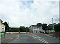
The large village of Wroughton lies 2 miles south of Swindon at the foot of the Marlborough Downs escarpment. Two headstreams of the River Ray flow from the downs and meet in the village to run north as Wroughton Stream. There is much evidence of settlement and intensive farming of the area in the Roman period. Originally an agricultural village, most workers now commute into Swindon.
Image: © Michael Dibb
Taken: 19 May 2018
0.04 miles
4
![Wroughton buildings [9]](https://s0.geograph.org.uk/geophotos/05/79/14/5791404_1e77c8c5_120x120.jpg)
Wroughton buildings [9]
A close look at the brickwork on the front of the former public house, now a shop Image The name 'The Three Tuns' is on the brickwork of the gable to the right of the image.
The large village of Wroughton lies 2 miles south of Swindon at the foot of the Marlborough Downs escarpment. Two headstreams of the River Ray flow from the downs and meet in the village to run north as Wroughton Stream. There is much evidence of settlement and intensive farming of the area in the Roman period. Originally an agricultural village, most workers now commute into Swindon.
Image: © Michael Dibb
Taken: 19 May 2018
0.04 miles
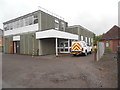
5
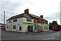
Co-operative food store on Devizes Road, Wroughton
Image: © JThomas
Taken: 13 Jul 2019
0.04 miles
9
Wroughton Telephone Exchange
Situated in Moormead Road, this building dates from the 1970s having replaced the former TE to the right of the photo, https://www.geograph.org.uk/photo/6577834 refers. It has the code SSWGN and provides telephone and broadband services to 3,283 residential and 137 non-residential premises in Wroughton plus Overtown nearby. A BT vehicle can be seen parked by the side of the TE. The numbering ranges of this TE are (01793) 81xxxx, 845xxx, the (01793) referring to the Swindon group of fourteen TEs, and its postcode is SN4 9BU.
Image: © David Hillas
Taken: 16 Aug 2019
0.09 miles
10
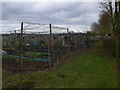
Wroughton allotments
Ready for spring planting.
Image: © Eirian Evans
Taken: 16 Feb 2011
0.11 miles