IMAGES TAKEN NEAR TO
Wroughton, SWINDON, SN4 9AQ
Introduction
This page details the photographs taken nearby to SN4 9AQ by members of the Geograph project.
The Geograph project started in 2005 with the aim of publishing, organising and preserving representative images for every square kilometre of Great Britain, Ireland and the Isle of Man.

There are currently over 7.5m images from over14,400 individuals and you can help contribute to the project by visiting https://www.geograph.org.uk
Image Map
Images are licensed for reuse under creativecommons.org/licenses/by-sa/2.0
Notes
- Clicking on the map will re-center to the selected point.
- The higher the marker number, the further away the image location is from the centre of the postcode.
Image Listing (9 Images Found)
Images are licensed for reuse under creativecommons.org/licenses/by-sa/2.0
Image
Details
Distance
5
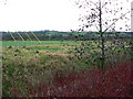
Farmland, North Wroughton, Swindon
The image was obtained from just inside Wroughton Business Park. The view is to the south east. Just about visible in the centre of the image is Wood Farm, just inside this square at SU156810.
Image: © Brian Robert Marshall
Taken: 13 Jan 2007
0.20 miles
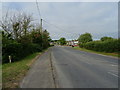
6
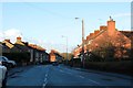
Swindon Road in North Wroughton
Looking towards Swindon.
Image: © Steve Daniels
Taken: 9 Feb 2014
0.21 miles
7
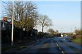
Moormead Road in Wroughton
Looking towards Swindon Road.
Image: © Steve Daniels
Taken: 9 Feb 2014
0.21 miles

9
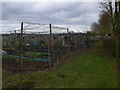
Wroughton allotments
Ready for spring planting.
Image: © Eirian Evans
Taken: 16 Feb 2011
0.25 miles