IMAGES TAKEN NEAR TO
Church Hill Close, SWINDON, SN4 8QW
Introduction
This page details the photographs taken nearby to Church Hill Close, SN4 8QW by members of the Geograph project.
The Geograph project started in 2005 with the aim of publishing, organising and preserving representative images for every square kilometre of Great Britain, Ireland and the Isle of Man.

There are currently over 7.5m images from over14,400 individuals and you can help contribute to the project by visiting https://www.geograph.org.uk
Image Map
Images are licensed for reuse under creativecommons.org/licenses/by-sa/2.0
Notes
- Clicking on the map will re-center to the selected point.
- The higher the marker number, the further away the image location is from the centre of the postcode.
Image Listing (21 Images Found)
Images are licensed for reuse under creativecommons.org/licenses/by-sa/2.0
Image
Details
Distance
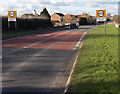
1
Stoneover Lane at the corner of Swindon Road
Image: © David Howard
Taken: 26 Oct 2019
0.03 miles
2
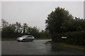
Stoneover Lane at the corner of Swindon Road
Image: © David Howard
Taken: 26 Oct 2019
0.03 miles
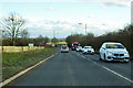
3
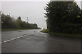
Road junction, Stoneover Lane
Junction of Stoneover Lane and the busy A3102 main road.
Image: © Vieve Forward
Taken: 3 Jan 2016
0.04 miles
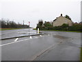
4
NE end of Stoneover Lane, Royal Wootton Bassett
At this junction with Swindon Road, turn left for other parts of Royal Wootton Bassett
or right for the M4 motorway and Swindon.
Image: © Jaggery
Taken: 2 Feb 2013
0.05 miles
5
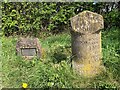
Old Milestone, Swindon Road, Royal Wootton Bassett
By the A3102, on the NE side of the road. In the parish of Lydiard Tregoze (North Wiltshire District), Swindon Road; opposite turn to Stoneover Lane and Noremarsh Lane, Royal Wootton Bassett, on grass at a lay-by used as bus stop, beside Golden Jubilee Stone. Inscription was re-cut for the Golden Jubilee in 2002.
Inscription reads:-
: TO / SWINDON / 5 Miles : : TO / BATH / 28 / Miles : : TO / OXFORD / 35 / Miles : : TO / WOOTTON / BASSETT / 1 Mile / TO / CHIPPENHAM / 15 Miles :
Jubilee Stone Inscription:
Parish of Lydiard Trgoz // to commemorate the // Golden Jubilee of //
her Majesty Queen Elizabeth II // 2002 // sponsored by Geoff and Tris Yates
Grade II listed.
List Entry Number: 1283221 https://historicengland.org.uk/listing/the-list/list-entry/1283221
Inscription: To / Bath / 28 / Miles //
To / Swindon / 5 / Miles //
To / Wotton / Basset / 1 Mile / to / Chippenham / 15 Miles //
To Oxford / 35 / Miles
Milestone Society National ID: WI_CPSN15
Image: © Jan Scrine
Taken: 31 Oct 2022
0.07 miles
6
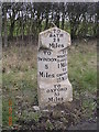
Old Milestone by the A3102, Swindon Road, Royal Wootton Bassett
Swindon waist by the A3102 (was A420), in parish of Lydiard Tregoze (North Wiltshire District), Swindon Road; opposite turn to Stoneover Lane and Noremarsh Lane, Royal Wootton Bassett, on grass at a lay-by used as bus stop, beside Golden Jubilee Stone. Inscription was re-cut for the Golden Jubilee in 2002.
Inscription reads:-
: TO / SWINDON / 5 Miles : : TO / BATH / 28 / Miles : : TO / OXFORD / 35 / Miles : : TO / WOOTTON / BASSETT / 1 Mile / TO / CHIPPENHAM / 15 Miles :
Grade II listed.
List Entry Number: 1283221 https://historicengland.org.uk/listing/the-list/list-entry/1283221
Surveyed
Milestone Society National ID: WI_cpsn15
Image: © Milestone Society
Taken: 7 Mar 2005
0.07 miles
7
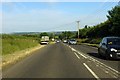
Swindon Road near Woodshaw
The A3102 runs from Royal Wootton Bassett to Swindon.
Image: © Steve Daniels
Taken: 25 Jun 2014
0.08 miles
8
Ravens Walk, Wootton Bassett
Near Swindon
Image: © Rick Crowley
Taken: 16 Aug 2002
0.12 miles
9
SE boundary of Coped Hall, Royal Wootton Bassett
The National Speed Limit along Swindon Road reduces to 40mph in the Coped Hall area of Royal Wootton Bassett.
Image: © Jaggery
Taken: 2 Feb 2013
0.16 miles
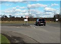
10
A3102 Swindon Road
Leaving Wootton Bassett towards Swindon.
Image: © Robin Webster
Taken: 2 Feb 2018
0.17 miles