IMAGES TAKEN NEAR TO
Hill View, SWINDON, SN4 7RQ
Introduction
This page details the photographs taken nearby to Hill View, SN4 7RQ by members of the Geograph project.
The Geograph project started in 2005 with the aim of publishing, organising and preserving representative images for every square kilometre of Great Britain, Ireland and the Isle of Man.

There are currently over 7.5m images from over14,400 individuals and you can help contribute to the project by visiting https://www.geograph.org.uk
Image Map
Images are licensed for reuse under creativecommons.org/licenses/by-sa/2.0
Notes
- Clicking on the map will re-center to the selected point.
- The higher the marker number, the further away the image location is from the centre of the postcode.
Image Listing (8 Images Found)
Images are licensed for reuse under creativecommons.org/licenses/by-sa/2.0
Image
Details
Distance
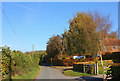
1
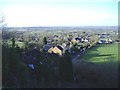
Broad Town
Viewed from halfway up the ridge to the north.
Image: © Roger Cornfoot
Taken: 21 Jan 2007
0.01 miles

3
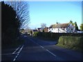
Crossroads at Broad Town
The White Horse Trail crosses the main road at this point.
Image: © Roger Cornfoot
Taken: 22 Jan 2007
0.04 miles
4
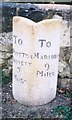
Old Milestone by Broad Town Road, Broad Town
Swindon thin 'D' stone by the UC road (was B4041), in parish of Broad Town (North Wiltshire District), Broad Town Road, in front of New Croft, housing development, on narrow lawn in front of stone boundary wall.
Inscription reads:-
: TO / WOOTTON / BASSETT / 3 / MILES : : TO / MARLBRO / 9 / MILES :
Grade II listed.
List Entry Number: 1363669 https://historicengland.org.uk/listing/the-list/list-entry/1363669
Surveyed
Milestone Society National ID: WI_mlwb09
Image: © Milestone Society
Taken: Unknown
0.09 miles
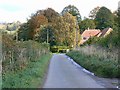
5
Pye Lane
The Broad Town White Horse can be seen on the escarpment in the distance.
Image: © Vieve Forward
Taken: 17 Feb 2017
0.15 miles
7
Pye Lane, Broad Town
The lane is seen heading east into the village of Broad Town.
Image: © Brian Robert Marshall
Taken: 21 Oct 2008
0.22 miles
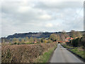
8
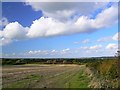
Farmland north of Pye Lane, Broad Town
The land slopes gently down towards the market town of Wootton Bassett just visible on the skyline about 5 kilometres away.
Image: © Brian Robert Marshall
Taken: 21 Oct 2008
0.25 miles