IMAGES TAKEN NEAR TO
Bushton Road, SWINDON, SN4 7QJ
Introduction
This page details the photographs taken nearby to Bushton Road, SN4 7QJ by members of the Geograph project.
The Geograph project started in 2005 with the aim of publishing, organising and preserving representative images for every square kilometre of Great Britain, Ireland and the Isle of Man.

There are currently over 7.5m images from over14,400 individuals and you can help contribute to the project by visiting https://www.geograph.org.uk
Image Map
Images are licensed for reuse under creativecommons.org/licenses/by-sa/2.0
Notes
- Clicking on the map will re-center to the selected point.
- The higher the marker number, the further away the image location is from the centre of the postcode.
Image Listing (5 Images Found)
Images are licensed for reuse under creativecommons.org/licenses/by-sa/2.0
Image
Details
Distance
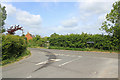
1
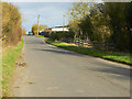
Bushton Road near Barnhill Farm, Broad Town
The information in the title came from Royal Mail. Broad Town is about 2 kilometres south of here.
Image: © Brian Robert Marshall
Taken: 2 Mar 2009
0.04 miles
2
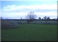
Barnhill farm
A pollarded willow stands by Brinkworth Brook.
Image: © Roger Cornfoot
Taken: 21 Jan 2007
0.05 miles
3
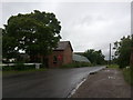
Looking across the road at Curtains by design
On a walk from Broad Town to Wootton Bassett
Image: © Matt Johnston
Taken: 2 Jul 2012
0.17 miles
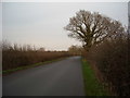
5
Phelps Lane
Road junction near Wootton Bassett.
Image: © Wayland Smith
Taken: 24 May 2020
0.25 miles