IMAGES TAKEN NEAR TO
Wood Street, SWINDON, SN4 7PZ
Introduction
This page details the photographs taken nearby to Wood Street, SN4 7PZ by members of the Geograph project.
The Geograph project started in 2005 with the aim of publishing, organising and preserving representative images for every square kilometre of Great Britain, Ireland and the Isle of Man.

There are currently over 7.5m images from over14,400 individuals and you can help contribute to the project by visiting https://www.geograph.org.uk
Image Map
Images are licensed for reuse under creativecommons.org/licenses/by-sa/2.0
Notes
- Clicking on the map will re-center to the selected point.
- The higher the marker number, the further away the image location is from the centre of the postcode.
Image Listing (6 Images Found)
Images are licensed for reuse under creativecommons.org/licenses/by-sa/2.0
Image
Details
Distance
1
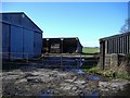
Farmyard on Wood Street
An isolated collection of farm buildings, north of Clyffe Pypard.
Image: © Roger Cornfoot
Taken: 21 Jan 2007
0.03 miles
2
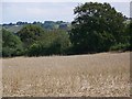
Stubble near Bushton
A field of oilseed rape stubble.
Image: © Maigheach-gheal
Taken: 9 Aug 2009
0.06 miles
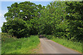
5
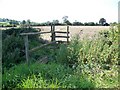
Footpath near Clyffe Pypard
After negotiating the footbridge and stile walkers cross fields to Hollyhouse Farm.
Image: © Maigheach-gheal
Taken: 9 Aug 2009
0.16 miles
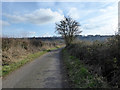
6
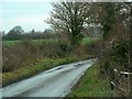
Wood Street, Clyffe Pypard
The street is really a country lane. It's been raining.
Image: © Brian Robert Marshall
Taken: 8 Dec 2008
0.21 miles