IMAGES TAKEN NEAR TO
Station Road, SWINDON, SN4 7EG
Introduction
This page details the photographs taken nearby to Station Road, SN4 7EG by members of the Geograph project.
The Geograph project started in 2005 with the aim of publishing, organising and preserving representative images for every square kilometre of Great Britain, Ireland and the Isle of Man.

There are currently over 7.5m images from over14,400 individuals and you can help contribute to the project by visiting https://www.geograph.org.uk
Image Map
Images are licensed for reuse under creativecommons.org/licenses/by-sa/2.0
Notes
- Clicking on the map will re-center to the selected point.
- The higher the marker number, the further away the image location is from the centre of the postcode.
Image Listing (54 Images Found)
Images are licensed for reuse under creativecommons.org/licenses/by-sa/2.0
Image
Details
Distance
1
Fire Station, Wootton Bassett
Despite being only about 170 metres north of this pub Image the Fire Brigade at this station were unable to stop the almost total destruction of the empty premises.
Image: © Brian Robert Marshall
Taken: 10 Sep 2009
0.02 miles
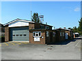
2

Wootton Bassett Fire Station
Wootton Bassett Fire Station, Station Road, Wootton Bassett, Wiltshire
Image: © Kevin Hale
Taken: 8 May 2007
0.02 miles
3
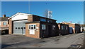
Royal Wootton Bassett Fire Station
Part of Wiltshire Fire & Rescue service, the fire station is located on the west side of Station Road.
Image: © Jaggery
Taken: 2 Feb 2013
0.03 miles
4
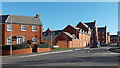
New houses, Station Road, Wootton Bassett
The new housing development taking place on a brownfield site looks rather more tidy than it did six months ago http://www.geograph.org.uk/photo/1210191
Image: © Brian Robert Marshall
Taken: 10 Sep 2009
0.04 miles
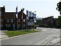
5
Station Road, Wootton Bassett
The entrance in the lower left corner leads to the town's fire station http://www.geograph.org.uk/photo/1481519 The new housing on the right is part of a large development on an old dairy factory http://www.geograph.org.uk/photo/1210189
Image: © Brian Robert Marshall
Taken: 10 Sep 2009
0.05 miles
6
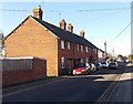
A short row of houses, New Road, Royal Wootton Bassett
One of the houses is named The Old Railway Cottage. This location is near the site of the demolished Wootton Bassett railway station.
Image: © Jaggery
Taken: 2 Feb 2013
0.08 miles
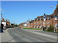
7
Cloatley Crescent, Royal Wootton Bassett
Recently-built houses on the east side of Station Road, viewed from the corner of New Road.
Image: © Jaggery
Taken: 2 Feb 2013
0.08 miles
8

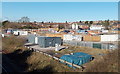
Regeneration, Station Road, Wootton Bassett
This site was once a huge dairy factory producing the well-known range of dairy products. Now it is being re-developed mainly for housing it would appear.
Image: © Brian Robert Marshall
Taken: 17 Mar 2009
0.08 miles
9
New Road building site, Royal Wootton Bassett
Viewed from this footbridge. http://www.geograph.org.uk/photo/3319868 The building site is on land formerly occupied by the Beaufort Arms pub, demolished after a fire in 2009. http://www.geograph.org.uk/photo/1481491
Image: © Jaggery
Taken: 2 Feb 2013
0.08 miles
10
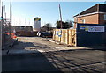
Entrance to a New Road building site, Royal Wootton Bassett
The site on the corner of New Road and Station Road was formerly occupied by the Beaufort Arms pub, demolished after a fire in 2009. http://www.geograph.org.uk/photo/1481491
Image: © Jaggery
Taken: 2 Feb 2013
0.09 miles