IMAGES TAKEN NEAR TO
Bath Road, SWINDON, SN4 7DF
Introduction
This page details the photographs taken nearby to Bath Road, SN4 7DF by members of the Geograph project.
The Geograph project started in 2005 with the aim of publishing, organising and preserving representative images for every square kilometre of Great Britain, Ireland and the Isle of Man.

There are currently over 7.5m images from over14,400 individuals and you can help contribute to the project by visiting https://www.geograph.org.uk
Image Map
Images are licensed for reuse under creativecommons.org/licenses/by-sa/2.0
Notes
- Clicking on the map will re-center to the selected point.
- The higher the marker number, the further away the image location is from the centre of the postcode.
Image Listing (45 Images Found)
Images are licensed for reuse under creativecommons.org/licenses/by-sa/2.0
Image
Details
Distance
1
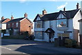
The Drove Veterinary Hospital, Royal Wootton Bassett
The name on the building at 12 Bath Road is Wootton Bassett Veterinary Surgery.
It is the Royal Wootton Bassett branch of the Drove Veterinary Hospital based in Swindon.
Image: © Jaggery
Taken: 2 Feb 2013
0.03 miles
2
New Road climbs towards Bath Road, Royal Wootton Bassett
Viewed from near the corner of Westbury Park. http://www.geograph.org.uk/photo/3329040
Image: © Jaggery
Taken: 2 Feb 2013
0.10 miles
3
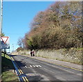
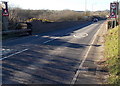
A not yet Royal road sign, Bath Road, Royal Wootton Bassett
The honour bestowed upon Wootton Bassett by Queen Elizabeth II in 2011 was a grant of royal patronage in recognition of the town's role in early 21st century military funeral repatriations.
Many names on display in the town now show Royal Wootton Bassett. Some do not yet. One example is this sign alongside Bath Road at the edge of Skew Bridge. It appears to be a town boundary sign but its main purpose is to mark the reduction in the speed limit from 50mph to 30mph. A grander sign http://www.geograph.org.uk/photo/3329205 several hundred metres behind the camera shows the changed name, and is presumably located at or near the town boundary.
Image: © Jaggery
Taken: 2 Feb 2013
0.10 miles
4
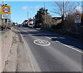
Junction at the southern end of High Street, Royal Wootton Bassett
Viewed across the A3012 which is named High Street to the left and Bath Road to the right.
Ahead, the vehicles are in Vale View. The road to the right past the Vale View junction is New Road.
Image: © Jaggery
Taken: 2 Feb 2013
0.10 miles
5
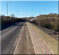
NE end of Skew Bridge, Royal Wootton Bassett
Skew Bridge is actually two bridges about 50 metres apart. The bridge ahead carries the A3102 Bath Road over the railway to and from South Wales via Bristol Parkway. The other bridge carries the railway to and from Bristol via Chippenham and Bath. The location is a few hundred metres west of the railway
junction. At the points where the road passes over, the South Wales line is orientated NW-SE
whereas the other tracks are orientated WNW-ESE hence the name Skew Bridge.
Image: © Jaggery
Taken: 2 Feb 2013
0.12 miles
6
Across the eastern part of Skew Bridge, Royal Wootton Bassett
Bath Road crosses railway lines. See http://www.geograph.org.uk/photo/3329197 for some notes about Skew Bridge.
Image: © Jaggery
Taken: 2 Feb 2013
0.13 miles
7
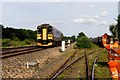
A sprinter train passes Wootton Bassett Sidings
The sprinter train runs from Swindon to Westbury.
Image: © Steve Daniels
Taken: 25 Jun 2014
0.13 miles
9
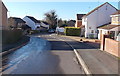
Eastern edge of Westbury Park, Royal Wootton Bassett
Viewed from the New Road end. Westbury Park is a large cul-de-sac
with about 90 houses located on the north side of railway lines.
Image: © Jaggery
Taken: 2 Feb 2013
0.14 miles
10
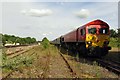
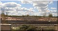
Discharge stone train waiting in Wootton Bassett sidings
Image: © Steve Daniels
Taken: 25 Jun 2014
0.14 miles