IMAGES TAKEN NEAR TO
High Street, SWINDON, SN4 7AS
Introduction
This page details the photographs taken nearby to High Street, SN4 7AS by members of the Geograph project.
The Geograph project started in 2005 with the aim of publishing, organising and preserving representative images for every square kilometre of Great Britain, Ireland and the Isle of Man.

There are currently over 7.5m images from over14,400 individuals and you can help contribute to the project by visiting https://www.geograph.org.uk
Image Map
Images are licensed for reuse under creativecommons.org/licenses/by-sa/2.0
Notes
- Clicking on the map will re-center to the selected point.
- The higher the marker number, the further away the image location is from the centre of the postcode.
Image Listing (119 Images Found)
Images are licensed for reuse under creativecommons.org/licenses/by-sa/2.0
Image
Details
Distance
1
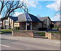
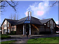
Entrance to Sacred Heart Parish Church, Royal Wootton Bassett
Viewed across High Street. Sacred Heart Parish Church is Royal Wootton Bassett's Roman Catholic church. This church was built early in the 1990s and dedicated in 1993. It replaced the church built in the early 1950s at the rear of the site. http://www.geograph.org.uk/photo/3406755 to another view.
Image: © Jaggery
Taken: 2 Feb 2013
0.03 miles
2
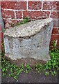
Milestone, Royal Wootton Bassett. A3102
Just off the High Street, re-located from possibly the NW side of the main road.
Erected by the Swindon and Christian Malford Turnpike Trust, in the 18ᵗʰ or 19ᵗʰ C.
Inscription (was): Swindon 6 // Chippenham 14 // To / (?) omford
Milestone Society National ID: WI_CPSN14
Image: © Tom Blanden
Taken: 8 Nov 2022
0.03 miles
3
Catholic Church of the Sacred Heart, High Street, Wootton Bassett
Built in the early 1990s, and dedicated in 1993. http://www.thesacredheartparish.co.uk/OurChurch.aspx
Image: © Vieve Forward
Taken: 3 Mar 2012
0.03 miles
4
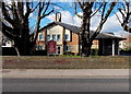
SE side of Sacred Heart Parish Church, Royal Wootton Bassett
Viewed across High Street. Sacred Heart Parish Church is Royal Wootton Bassett's Roman Catholic church. This church was built early in the 1990s and dedicated in 1993. It replaced the church built in the early 1950s at the rear of the site.
http://www.geograph.org.uk/photo/3406757 to another view.
Image: © Jaggery
Taken: 2 Feb 2013
0.03 miles
5
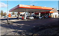
Total filling station and shop, Royal Wootton Bassett
Located at 91-93 High Street, formerly a Shell filling station.
Image: © Jaggery
Taken: 2 Feb 2013
0.04 miles
6
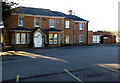
Royal Wootton Bassett police station
Part of the Wiltshire Police force, the station is on the corner of High Street and Lime Kiln. This view is across High Street.
Image: © Jaggery
Taken: 2 Feb 2013
0.06 miles
7
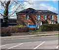
Manor House Child Health Clinic, Royal Wootton Bassett
Located on the south side of the street named Lime Kiln, near the corner of High Street.
Image: © Jaggery
Taken: 2 Feb 2013
0.07 miles
8
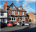
Wiltshire's first pub theatre, Red Lion, Royal Wootton Bassett
The Red Lion is at 59 High Street. To the left of the RED LION nameboard, another board shows Wiltshire's first PUB theatre.
Image: © Jaggery
Taken: 2 Feb 2013
0.08 miles
9
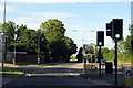
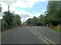
High Street in Royal Wootton Bassett
Lime Kiln on the left leads to the Police Station and Leisure Centre.
Image: © Steve Daniels
Taken: 25 Jun 2014
0.08 miles