IMAGES TAKEN NEAR TO
High Street, SWINDON, SN4 7AA
Introduction
This page details the photographs taken nearby to High Street, SN4 7AA by members of the Geograph project.
The Geograph project started in 2005 with the aim of publishing, organising and preserving representative images for every square kilometre of Great Britain, Ireland and the Isle of Man.

There are currently over 7.5m images from over14,400 individuals and you can help contribute to the project by visiting https://www.geograph.org.uk
Image Map
Images are licensed for reuse under creativecommons.org/licenses/by-sa/2.0
Notes
- Clicking on the map will re-center to the selected point.
- The higher the marker number, the further away the image location is from the centre of the postcode.
Image Listing (206 Images Found)
Images are licensed for reuse under creativecommons.org/licenses/by-sa/2.0
Image
Details
Distance
1
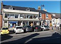
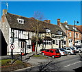
Royal Wootton Bassett Mini Mart
Located at 18-19 High Street, Royal Wootton Bassett.
There is a SHOP TO LET notice in an upstairs window.
Image: © Jaggery
Taken: 2 Feb 2013
0.00 miles
2
Chillies Indian Restaurant, Royal Wootton Bassett
Located at 21 High Street. Next door is The George Veterinary Group.
The top of the tower of this http://www.geograph.org.uk/photo/3378506 church is in the background.
Image: © Jaggery
Taken: 2 Feb 2013
0.01 miles
3
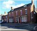
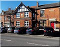
Grade II listed 156 High Street, Royal Wootton Bassett
There are many listed buildings in High Street, Royal Wootton Bassett.
This one, on the corner of Beamans Lane, dates from the 18th century, with later alterations.
It was Grade II listed in January 1955.
Image: © Jaggery
Taken: 2 Feb 2013
0.02 miles
4
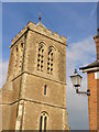
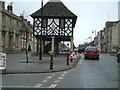
St Bartholomew Tower
Massive stone tower at the east end of Wootton Bassett's medieval parish church, St Bartholomew and All Saints.
http://www.woottonbassett.gov.uk/
Image: © Colin Smith
Taken: 31 May 2010
0.02 miles
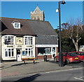
5
The Waggon & Horses viewed from the south, Royal Wootton Bassett
Pub at 9 High Street. The large shadow on the left is being cast on a wall at the corner of Rope Yard.
Image: © Jaggery
Taken: 2 Feb 2013
0.02 miles
6
A late Victorian house, High Street, Royal Wootton Bassett
Below the black and white part of the house, the year 1887 is inscribed on the wall.
Image: © Jaggery
Taken: 2 Feb 2013
0.02 miles
7
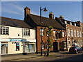
The Cross Keys
Old coaching inn on Wootton Bassett High Street beside a more modern branch of Barclays Bank.
http://www.woottonbassett.gov.uk/
Image: © Colin Smith
Taken: 31 May 2010
0.03 miles
9

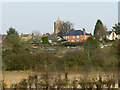
Wootton Bassett from west of Broad Town
The church tower on the skyline is at SU06618251. It belongs to St Bartholomew & All Saints Church in the town. There are photographs of the church here http://www.oodwooc.co.uk/ph_wb.htm#external and this is the website for the church http://www.stbartholomews-wb.com/
Thanks to a fellow contributor for providing the name of the church.
Update March 2011: Wootton Bassett will soon become a member of a very exclusive club when the letters patent are signed by the Queen entitling the town to be known as Royal Wootton Bassett http://www.bbc.co.uk/news/uk-england-wiltshire-12757984
Image: © Brian Robert Marshall
Taken: 21 Oct 2008
0.03 miles
10
St Bartholomew & All Saints Church, Wootton Bassett
The church occupies a prominent position in the town and can be seen for some distance around from the south and west. There is more information in the description of this image http://www.geograph.org.uk/photo/1015787 The residential properties seen here are in Church Street and Rope Yard.
Image: © Brian Robert Marshall
Taken: 17 Mar 2009
0.03 miles