1
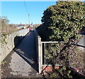
Road from car park to Wilts & Berks Canal terminus at Templar's Firs, Royal Wootton Bassett, Wilts
There is a small car parking area off Marlborough Road which is used by visitors to the restored section of canal at Templar's Firs. This road connects the car park to the canal's terminus and is also used for access to nearby fields. A public footpath runs along this road as far as the canal terminus and then continues along the towpath of the canal.
Image
Image: © P L Chadwick
Taken: 24 Sep 2017
0.06 miles
2
Houses in Glenville Close
Image: © Steve Daniels
Taken: 25 Jun 2014
0.08 miles
3
Passing through the flood
A view looking to the west as a First Great Western HS125 slowly passes through the flooded section of track at Wootton Bassett.
Image: © Phil Williams
Taken: 11 Jan 2008
0.13 miles
4
Temporary highway, Royal Wootton Bassett, Wiltshire (2 of 2)
The main railway from London Paddington to the west country and Wales is being converted to electric traction. One of the engineering challenges at various places along the line is providing sufficient headroom to allow the power cables to pass beneath bridges over the line. The preferred option is to raise the bridge by the required amount. In some cases where the bridge is a listed building the alternative is to lower the track-bed. In Royal Wootton Bassett there are three road bridges which have to be raised over the next couple of years. In order to minimise disruption to road traffic a temporary road has been built that will allow traffic to enter the town from the south and west without having to make the massive detours that would otherwise be necessary. The first bridge to be raised is the easternmost of the three known locally as Broad Town Bridge at SU06988174. When that has been completed and the road it carries reopened, attention will be turned to the pair of bridges known collectively as Skew Bridge which lie either side of SU06168197. As is inevitable with large infrastructure projects this one has generated some controversy locally with local residents complaining about lack of privacy and increased noise. Despite assurances there is also a fear that the road will be made permanent. This east-facing image shows the fence installed as part of the sound-reduction and privacy strategy.
Image: © Brian Robert Marshall
Taken: 8 Mar 2016
0.15 miles
5
Train passing Wootton Bassett
A Paddington express speeds past the Southern edge of this Wiltshire commuter town.
Image: © Roger Cornfoot
Taken: 2 Jan 2007
0.15 miles
6
Track on the south side of the railway, Royal Wootton Bassett
The track heads away from the access lane http://www.geograph.org.uk/photo/3329025 to the Johnson Aggregates site in Railstone Terminal.
Image: © Jaggery
Taken: 2 Feb 2013
0.16 miles
7
Railway footbridge, Royal Wootton Bassett
This bridge for pedestrians is on the west side of the road bridge http://www.geograph.org.uk/photo/3319862 which is too narrow for pavements. It crosses railway lines near the site of the demolished Wootton Bassett railway station.
Image: © Jaggery
Taken: 2 Feb 2013
0.16 miles
8
Railway to the West Country, Royal Wootton Bassett
This is Isambard Kingdom Brunel's signature railway running from London Paddington, behind the viewpoint, to Bristol. The line is due to be electrified and has much of the infrastructure in place for that but, at the time this photo was taken, the system had not been connected to the power supply.
Image: © Brian Robert Marshall
Taken: 15 Sep 2018
0.16 miles
9
Broad Town Road railway bridge, Royal Wootton Bassett
The road across the bridge is Marlborough Road leading to Station Road. The identifier on the bridge shows Broad Town Road 82m 68.5c MLN1. There is a side bridge on the left for pedestrians. http://www.geograph.org.uk/photo/3319868
The location is near the site of the demolished Wootton Bassett railway station.
Image: © Jaggery
Taken: 2 Feb 2013
0.17 miles
10
Templar's Firs slipway, Wilts & Berks Canal, Royal Wootton Bassett
A restored stretch of the Wilts & Berks Canal ends abruptly here at the Templar's Firs slipway. The slipway was built in 1995 for launching the trip boat of the local branch of the Wilts & Berks Canal Trust, but trips were found not to be financially viable, so were discontinued. http://homepage.ntlworld.com/pasmith.wbcanal/ml/sect22.htm http://www.wbct.org.uk/
Image: © Vieve Forward
Taken: 8 Oct 2013
0.17 miles


