IMAGES TAKEN NEAR TO
Halton Crescent, SWINDON, SN4 0TT
Introduction
This page details the photographs taken nearby to Halton Crescent, SN4 0TT by members of the Geograph project.
The Geograph project started in 2005 with the aim of publishing, organising and preserving representative images for every square kilometre of Great Britain, Ireland and the Isle of Man.

There are currently over 7.5m images from over14,400 individuals and you can help contribute to the project by visiting https://www.geograph.org.uk
Image Map
Images are licensed for reuse under creativecommons.org/licenses/by-sa/2.0
Notes
- Clicking on the map will re-center to the selected point.
- The higher the marker number, the further away the image location is from the centre of the postcode.
Image Listing (13 Images Found)
Images are licensed for reuse under creativecommons.org/licenses/by-sa/2.0
Image
Details
Distance
1
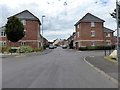
Alexandra Park, Swindon
This relatively small development of new houses is on the site of a former RAF hospital. The stone and plaque at the lower left of the image can be seen in close-up here http://www.geograph.org.uk/photo/837750 There is quite a large abstract sculpture present as well.
Image: © Brian Robert Marshall
Taken: 9 Jun 2008
0.05 miles
2
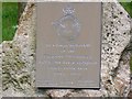
Commemorative plaque, Alexandra Park, Swindon
The plaque is attached to a sarsen stone. The hospital that once stood here took casualties from various theatres of war from 1941 until closure. These theatres are reflected in the road names in the new housing development that has risen in its place. One of the more well-known patients to be treated here was the Welsh guardsman Simon Weston, severely wounded aboard the Sir Galahad in the South Atlantic conflict of 1982. One of the roads is Falklands Road.
Image: © Brian Robert Marshall
Taken: 9 Jun 2008
0.05 miles
3
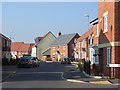
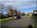
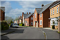
Whittingham Drive, Alexandra Park, Wroughton
This new development has gone up on a brownfield site. Here it has the appearance of modern bit of suburbia but is actually pleasantly located in farmland beneath the downs.
Image: © Andrew Smith
Taken: 16 Feb 2008
0.05 miles
4
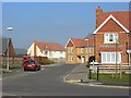
Falklands Road, Alexandra Park, Wroughton
Part of a new development in the countryside to the south of Swindon. The housing doesn't have the uniform appearance that you sometimes see. It's also nice to see flints incorporated into modern architecture.
Image: © Andrew Smith
Taken: 16 Feb 2008
0.05 miles
5
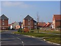
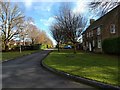
Alexandra Park, Wroughton
Looking into the new housing development from the road up to Barbury Castle.
Image: © Andrew Smith
Taken: 16 Feb 2008
0.05 miles
6
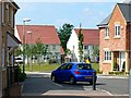
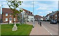
Normandy Road, Alexandra Park, Swindon
Alexandra Park is a private sector housing development built on the site of a former RAF hospital opened in 1941 and closed 54 years later. Road names are taken from famous theatres of war.
Image: © Brian Robert Marshall
Taken: 9 Jun 2008
0.08 miles
8
Normandy Road, Alexandra Park, Wroughton
Modern houses within an estate built on the site of former RAF hospital.
Image: © Andrew Smith
Taken: 7 May 2023
0.10 miles