IMAGES TAKEN NEAR TO
Wroughton, SWINDON, SN4 0SH
Introduction
This page details the photographs taken nearby to SN4 0SH by members of the Geograph project.
The Geograph project started in 2005 with the aim of publishing, organising and preserving representative images for every square kilometre of Great Britain, Ireland and the Isle of Man.

There are currently over 7.5m images from over14,400 individuals and you can help contribute to the project by visiting https://www.geograph.org.uk
Image Map
Images are licensed for reuse under creativecommons.org/licenses/by-sa/2.0
Notes
- Clicking on the map will re-center to the selected point.
- The higher the marker number, the further away the image location is from the centre of the postcode.
Image Listing (5 Images Found)
Images are licensed for reuse under creativecommons.org/licenses/by-sa/2.0
Image
Details
Distance
1
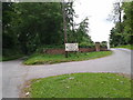
The top of Overtown Hill, signs to Overtown Manor and Engine Shed, right, and Overtown Farm, left
Image: © Rob Purvis
Taken: 14 Jun 2013
0.07 miles
2
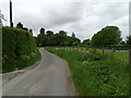
Lane heading to Wroughton at Overtown House
Image: © Rob Purvis
Taken: 14 Jun 2013
0.10 miles
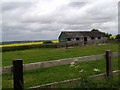
4
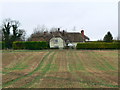
Parsloe's Farm, Overtown, Wroughton, Swindon
The actual farmhouse would seem to be the white-painted building at the right of the image. It has a thatched roof.
Image: © Brian Robert Marshall
Taken: 13 Jan 2007
0.21 miles
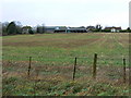
5
Parsloe's Farm, Overtown, Wroughton, Swindon
A closer view of the farmhouse. From the air its footprint is reminiscent of a continental '7'.
Image: © Brian Robert Marshall
Taken: 13 Jan 2007
0.21 miles