IMAGES TAKEN NEAR TO
Wroughton, SWINDON, SN4 0QZ
Introduction
This page details the photographs taken nearby to SN4 0QZ by members of the Geograph project.
The Geograph project started in 2005 with the aim of publishing, organising and preserving representative images for every square kilometre of Great Britain, Ireland and the Isle of Man.

There are currently over 7.5m images from over14,400 individuals and you can help contribute to the project by visiting https://www.geograph.org.uk
Image Map
Images are licensed for reuse under creativecommons.org/licenses/by-sa/2.0
Notes
- Clicking on the map will re-center to the selected point.
- The higher the marker number, the further away the image location is from the centre of the postcode.
Image Listing (6 Images Found)
Images are licensed for reuse under creativecommons.org/licenses/by-sa/2.0
Image
Details
Distance
1
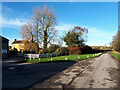
Hackpen Farm
Former RAF Wroughton in the distance.
Image: © Vieve Forward
Taken: 25 Dec 2020
0.02 miles
2
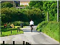
The road past Hackpen Farm, Swindon
The farm entrance is to the left. Ahead can be seen part of a residential property and beyond that a building on the old wartime Wroughton Airfield.
Image: © Brian Robert Marshall
Taken: 9 Jun 2008
0.04 miles
3
![Wroughton Airfield [7]](https://s3.geograph.org.uk/geophotos/05/06/57/5065743_5df4bfa4_120x120.jpg)
Wroughton Airfield [7]
The airfield opened in 1940 and the 545 acre site was acquired by the Science Museum in 1979. It is used for large object storage, there are many exhibits such as cars, trains, planes, and hovercraft. The Museum's library is also on the site. Other businesses are located on the site. This is one of the entrances to the airfield.
Image: © Michael Dibb
Taken: 5 Aug 2016
0.15 miles
4
![Wroughton Airfield [8]](https://s0.geograph.org.uk/geophotos/05/06/57/5065744_41be24ef_120x120.jpg)
Wroughton Airfield [8]
The airfield opened in 1940 and the 545 acre site was acquired by the Science Museum in 1979. It is used for large object storage, there are many exhibits such as cars, trains, planes, and hovercraft. The Museum's library is also on the site. Other businesses are located on the site, using these buildings as offices.
Image: © Michael Dibb
Taken: 5 Aug 2016
0.24 miles
5
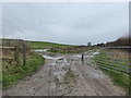
Field near Hackpen Farm
Muddy field entrance.
Image: © Vieve Forward
Taken: 1 Jan 2016
0.24 miles
6
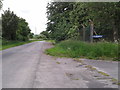
Road heading south on the east side of Wroughton airfield
Image: © Rob Purvis
Taken: 14 Jun 2013
0.25 miles