IMAGES TAKEN NEAR TO
Thorney Park, SWINDON, SN4 0QS
Introduction
This page details the photographs taken nearby to Thorney Park, SN4 0QS by members of the Geograph project.
The Geograph project started in 2005 with the aim of publishing, organising and preserving representative images for every square kilometre of Great Britain, Ireland and the Isle of Man.

There are currently over 7.5m images from over14,400 individuals and you can help contribute to the project by visiting https://www.geograph.org.uk
Image Map
Images are licensed for reuse under creativecommons.org/licenses/by-sa/2.0
Notes
- Clicking on the map will re-center to the selected point.
- The higher the marker number, the further away the image location is from the centre of the postcode.
Image Listing (9 Images Found)
Images are licensed for reuse under creativecommons.org/licenses/by-sa/2.0
Image
Details
Distance
1
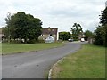
Thorney Park
One of the entrances to Thorney Park. The estate was once the housing for personnel stationed at Wroughton Airfield.
Image: © Michael Dibb
Taken: 5 Aug 2016
0.12 miles
3
![Wroughton Airfield [6]](https://s0.geograph.org.uk/geophotos/05/06/43/5064384_2a24c524_120x120.jpg)
Wroughton Airfield [6]
The airfield opened in 1940 and the 545 acre site was acquired by the Science Museum in 1979. It is used for large object storage, there are many exhibits such as cars, trains, planes, and hovercraft. The Museum's library is also on the site. Other businesses are located on the site and one of them use this hangar. It is noticeable that this hangar is not as well maintained as those used by the museum Image and Image
Image: © Michael Dibb
Taken: 5 Aug 2016
0.18 miles
4
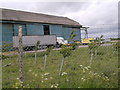
Lorries outside a hangar at Wroughton airfield
Image: © Rob Purvis
Taken: 14 Jun 2013
0.18 miles
5
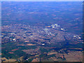
Swindon from the air
Wroughton and the north end of Wroughton airfield can be seen at the bottom of the photo.
Image: © Thomas Nugent
Taken: 11 Oct 2010
0.19 miles
6
![Wroughton Airfield [4]](https://s3.geograph.org.uk/geophotos/05/06/43/5064307_c12fc0f8_120x120.jpg)
Wroughton Airfield [4]
The airfield opened in 1940 and the 545 acre site was acquired by the Science Museum in 1979. It is used for large object storage, there are many exhibits such as cars, trains, planes, and hovercraft. The Museum's library is also on the site. Other businesses also use part of the site. This is one of the hangars, partly obscured by another small building surrounded by an earthen berm.
Image: © Michael Dibb
Taken: 5 Aug 2016
0.21 miles
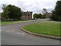
7
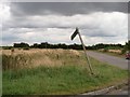
Path leaves the road
A public footpath leaves the minor road at this point. The path leads to Beranburh Field which was where the officers serving at Wroughton Airfield had their housing.
Image: © Michael Dibb
Taken: 5 Aug 2016
0.21 miles
8
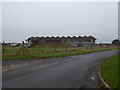
Aircraft hangar, Wroughton Airfield
RAF Wroughton was opened in 1940. https://en.wikipedia.org/wiki/RAF_Wroughton It now belongs to the Science Museum Group. http://www.sciencemuseum.org.uk/wroughton/
Image: © Vieve Forward
Taken: 1 Jan 2016
0.21 miles
9
![Wroughton Airfield [5]](https://s3.geograph.org.uk/geophotos/05/06/43/5064367_d91457a1_120x120.jpg)
Wroughton Airfield [5]
The airfield opened in 1940 and the 545 acre site was acquired by the Science Museum in 1979. It is used for large object storage, there are many exhibits such as cars, trains, planes, and hovercraft. The Museum's library is also on the site. Other businesses are on the airfield like this indoor karting company using the hangar seen to the side of the sign.
Image: © Michael Dibb
Taken: 5 Aug 2016
0.23 miles