
IMAGES TAKEN NEAR TO
Preddy Close, SN4 0GG
Introduction
This page details the photographs taken nearby to Preddy Close, SN4 0GG by members of the Geograph project.
The Geograph project started in 2005 with the aim of publishing, organising and preserving representative images for every square kilometre of Great Britain, Ireland and the Isle of Man.

There are currently over 7.5m images from over14,400 individuals and you can help contribute to the project by visiting https://www.geograph.org.uk
Image Map
Images are licensed for reuse under creativecommons.org/licenses/by-sa/2.0
Notes
- Clicking on the map will re-center to the selected point.
- The higher the marker number, the further away the image location is from the centre of the postcode.
Image Listing (54 Images Found)
Images are licensed for reuse under creativecommons.org/licenses/by-sa/2.0
Image
Details
Distance
1
![Wroughton houses [9]](https://s1.geograph.org.uk/geophotos/05/79/14/5791417_4a56b826_120x120.jpg)
Wroughton houses [9]
The Gables is a fine four square house in Marlborough Road.
The large village of Wroughton lies 2 miles south of Swindon at the foot of the Marlborough Downs escarpment. Two headstreams of the River Ray flow from the downs and meet in the village to run north as Wroughton Stream. There is much evidence of settlement and intensive farming of the area in the Roman period. Originally an agricultural village, most workers now commute into Swindon.
Image: © Michael Dibb
Taken: 19 May 2018
0.10 miles
2
![Wroughton features [3]](https://s1.geograph.org.uk/geophotos/05/79/14/5791425_f38a53b4_120x120.jpg)
Wroughton features [3]
This George VI postbox is seen on the corner of Marlborough Road and The Pitchens.
The large village of Wroughton lies 2 miles south of Swindon at the foot of the Marlborough Downs escarpment. Two headstreams of the River Ray flow from the downs and meet in the village to run north as Wroughton Stream. There is much evidence of settlement and intensive farming of the area in the Roman period. Originally an agricultural village, most workers now commute into Swindon.
Image: © Michael Dibb
Taken: 19 May 2018
0.11 miles
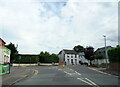
4
![Wroughton houses [35]](https://s2.geograph.org.uk/geophotos/06/42/38/6423814_f272fc2f_120x120.jpg)
Wroughton houses [35]
Windshot House, number 45 Marlborough Road, occupies a prominent position at the foot of Brimble Hill.
The large village of Wroughton lies 2 miles south of Swindon at the foot of the Marlborough Downs escarpment. Two headstreams of the River Ray flow from the downs and meet in the village to run north as Wroughton Stream. There is much evidence of settlement and intensive farming of the area in the Roman period. Originally an agricultural village, most workers now commute into Swindon.
Image: © Michael Dibb
Taken: 11 Mar 2020
0.14 miles
5
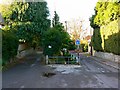
Private road and The Pitchens, Wroughton, Swindon
The private road is to the left near the sign in this image Image The Pitchens is shown as a no through road but there is a footpath through.
Image: © Brian Robert Marshall
Taken: 12 Nov 2007
0.15 miles
6
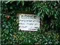
'No public right of way', The Pitchens, Wroughton, Swindon
The Rights of Way Act 1932 permitted an owner of land to post a sign such as the one pictured making it clear that a path over the land is not a right of way. That's how I read it anyway. http://www.glass-uk.org/index.php?option=com_content&task=view&id=236&Itemid=455
Image: © Brian Robert Marshall
Taken: 12 Nov 2007
0.15 miles
7
![Wroughton houses [10]](https://s0.geograph.org.uk/geophotos/05/79/24/5792468_1150c228_120x120.jpg)
Wroughton houses [10]
The Lodge is a fine, 18th century thatched cottages is listed, grade II, with details at: https://www.historicengland.org.uk/listing/the-list/list-entry/1185769
The large village of Wroughton lies 2 miles south of Swindon at the foot of the Marlborough Downs escarpment. Two headstreams of the River Ray flow from the downs and meet in the village to run north as Wroughton Stream. There is much evidence of settlement and intensive farming of the area in the Roman period. Originally an agricultural village, most workers now commute into Swindon.
Image: © Michael Dibb
Taken: 19 May 2018
0.15 miles
8
![Wroughton houses [11]](https://s0.geograph.org.uk/geophotos/05/79/14/5791472_574c4693_120x120.jpg)
Wroughton houses [11]
Woodham House is a fine 19th century house. Listed, grade II, with details at: https://www.historicengland.org.uk/listing/the-list/list-entry/1185596
The large village of Wroughton lies 2 miles south of Swindon at the foot of the Marlborough Downs escarpment. Two headstreams of the River Ray flow from the downs and meet in the village to run north as Wroughton Stream. There is much evidence of settlement and intensive farming of the area in the Roman period. Originally an agricultural village, most workers now commute into Swindon.
Image: © Michael Dibb
Taken: 19 May 2018
0.15 miles
9
![Wroughton buildings [10]](https://s1.geograph.org.uk/geophotos/05/79/24/5792457_2b628bc8_120x120.jpg)
Wroughton buildings [10]
Now converted into dwellings, this early 19th century mill, The Old Mill, is listed, grade II, with details at: https://www.historicengland.org.uk/listing/the-list/list-entry/1023434
The large village of Wroughton lies 2 miles south of Swindon at the foot of the Marlborough Downs escarpment. Two headstreams of the River Ray flow from the downs and meet in the village to run north as Wroughton Stream. There is much evidence of settlement and intensive farming of the area in the Roman period. Originally an agricultural village, most workers now commute into Swindon.
Image: © Michael Dibb
Taken: 19 May 2018
0.15 miles
10
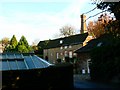
Woodman House, Baker's Road, Wroughton, Swindon
Probably early 19th century, this used to be a water mill. More here courtesy of English Heritage http://www.imagesofengland.org.uk/details/default.aspx?id=318599
Image: © Brian Robert Marshall
Taken: 12 Nov 2007
0.15 miles