IMAGES TAKEN NEAR TO
Horpit, SWINDON, SN4 0AT
Introduction
This page details the photographs taken nearby to Horpit, SN4 0AT by members of the Geograph project.
The Geograph project started in 2005 with the aim of publishing, organising and preserving representative images for every square kilometre of Great Britain, Ireland and the Isle of Man.

There are currently over 7.5m images from over14,400 individuals and you can help contribute to the project by visiting https://www.geograph.org.uk
Image Map
Images are licensed for reuse under creativecommons.org/licenses/by-sa/2.0
Notes
- Clicking on the map will re-center to the selected point.
- The higher the marker number, the further away the image location is from the centre of the postcode.
Image Listing (4 Images Found)
Images are licensed for reuse under creativecommons.org/licenses/by-sa/2.0
Image
Details
Distance
1
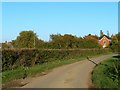
Horpit, Wanborough, Swindon
Off the beaten track but popular with cyclists and walkers.
Image: © Brian Robert Marshall
Taken: 12 Oct 2008
0.06 miles
3
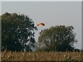
Maize and trees, Horpit, Wanborough
The maize looks as if it is about ready to be harvested.
Image: © Brian Robert Marshall
Taken: 12 Oct 2008
0.09 miles
4
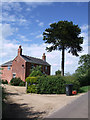
Breach Farm Cottage, with monkey puzzle tree
Breach Farm Cottage boasts this magnificent monkey puzzle tree in its front garden.
Image: © Vieve Forward
Taken: 9 Jun 2012
0.23 miles