IMAGES TAKEN NEAR TO
The Marsh, SWINDON, SN4 0AR
Introduction
This page details the photographs taken nearby to The Marsh, SN4 0AR by members of the Geograph project.
The Geograph project started in 2005 with the aim of publishing, organising and preserving representative images for every square kilometre of Great Britain, Ireland and the Isle of Man.

There are currently over 7.5m images from over14,400 individuals and you can help contribute to the project by visiting https://www.geograph.org.uk
Image Map
Images are licensed for reuse under creativecommons.org/licenses/by-sa/2.0
Notes
- Clicking on the map will re-center to the selected point.
- The higher the marker number, the further away the image location is from the centre of the postcode.
Image Listing (4 Images Found)
Images are licensed for reuse under creativecommons.org/licenses/by-sa/2.0
Image
Details
Distance
1
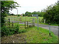
Diverging footpaths west of Wanborough
These head west and south from Burycroft Common.
Image: © Jonathan Billinger
Taken: 21 Jul 2009
0.13 miles
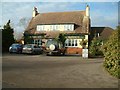
2
Marsh Farm
Half a mile from the bustle of Swindon, the footpath starting here crosses open fields to the east of the A419.
Image: © Jonathan Billinger
Taken: 4 Jan 2007
0.13 miles
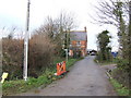
4
Path going across footbridge to Wanborough Marsh
Path near Foxbridge Farm going across footbridge to Wanborough Marsh
Image: © Shaun Ferguson
Taken: 8 Mar 2012
0.23 miles