IMAGES TAKEN NEAR TO
Boldrewood, SWINDON, SN3 6JP
Introduction
This page details the photographs taken nearby to Boldrewood, SN3 6JP by members of the Geograph project.
The Geograph project started in 2005 with the aim of publishing, organising and preserving representative images for every square kilometre of Great Britain, Ireland and the Isle of Man.

There are currently over 7.5m images from over14,400 individuals and you can help contribute to the project by visiting https://www.geograph.org.uk
Image Map
Images are licensed for reuse under creativecommons.org/licenses/by-sa/2.0
Notes
- Clicking on the map will re-center to the selected point.
- The higher the marker number, the further away the image location is from the centre of the postcode.
Image Listing (17 Images Found)
Images are licensed for reuse under creativecommons.org/licenses/by-sa/2.0
Image
Details
Distance
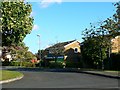
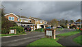
1
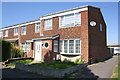
Houses on west side of Liden Drive
There is an OS benchmark Image on the right hand side of the near house at its front corner
Image: © Roger Templeman
Taken: 22 Apr 2015
0.11 miles
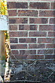
2
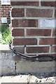
Benchmark on #6 Mackenzie
Ordnance Survey cut mark benchmark described on the Bench Mark Database at http://www.bench-marks.org.uk/bm66198
Image: © Roger Templeman
Taken: 22 Apr 2015
0.12 miles
3
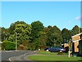
Fairlawn, Swindon
This is another view of the small estate of 'executive' homes on the south-eastern edge of Swindon also shown in this image http://www.geograph.org.uk/photo/989161
Image: © Brian Robert Marshall
Taken: 1 Oct 2008
0.13 miles
4
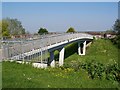
Footbridge over Dorcan Way
Taken from the Eldene end looking towards Liden.
Image: © David Martin
Taken: 22 May 2012
0.15 miles
5
Fairlawn, Swindon
The description in this image http://www.geograph.org.uk/photo/989141 has a brief history of this area. Fairlawn was developed in the early 1970s by a private developer specializing in what were known at the time as 'executive' homes. They remain very popular.
Image: © Brian Robert Marshall
Taken: 1 Oct 2008
0.17 miles
6
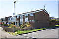
Houses on Conan Doyle Walk
There is an OS benchmark Image on the near corner of the porch of the near house
Image: © Roger Templeman
Taken: 22 Apr 2015
0.18 miles
7
Benchmark on porch of #1 Conan Doyle Walk
Ordnance Survey cut mark benchmark described on the Bench Mark Database at http://www.bench-marks.org.uk/bm66199
Image: © Roger Templeman
Taken: 22 Apr 2015
0.19 miles
8
Junction of Liden Drive and Okebourne Park (north end)
Image: © Roger Templeman
Taken: 22 Apr 2015
0.20 miles
9
Solid street name signs, Fairlawn
In large letters on brick plinths.
Image: © Des Blenkinsopp
Taken: 9 Nov 2022
0.21 miles
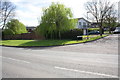
10
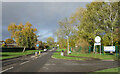
Liden Drive, Swindon
The main road for the area, Liden Drive goes in a big loop serving all the short residential streets which branch off it.
Image: © Des Blenkinsopp
Taken: 9 Nov 2022
0.23 miles