IMAGES TAKEN NEAR TO
St. Ambrose Close, SWINDON, SN3 5EG
Introduction
This page details the photographs taken nearby to St. Ambrose Close, SN3 5EG by members of the Geograph project.
The Geograph project started in 2005 with the aim of publishing, organising and preserving representative images for every square kilometre of Great Britain, Ireland and the Isle of Man.

There are currently over 7.5m images from over14,400 individuals and you can help contribute to the project by visiting https://www.geograph.org.uk
Image Map
Images are licensed for reuse under creativecommons.org/licenses/by-sa/2.0
Notes
- Clicking on the map will re-center to the selected point.
- The higher the marker number, the further away the image location is from the centre of the postcode.
Image Listing (19 Images Found)
Images are licensed for reuse under creativecommons.org/licenses/by-sa/2.0
Image
Details
Distance
1
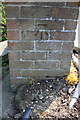
Benchmark on bridge pier at entrance to The Dorcan Academy
Ordnance Survey cut mark benchmark described on the Bench Mark Database at http://www.bench-marks.org.uk/bm56147
Image: © Roger Templeman
Taken: 9 Apr 2015
0.08 miles
2
Bridge over Dorcan Stream from St Paul's Drive
There is an OS benchmark Image on the bridge pier left of the centre of the image
Image: © Roger Templeman
Taken: 9 Apr 2015
0.08 miles
3
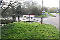
Junction of Pinnegar Way and St Paul's Drive
There was a bus stop shelter which had an Ordnance Survey benchmark ( http://www.bench-marks.org.uk/bm56146 ) on the left hand side of St Paul's Drive where just a concrete base and bus stop sign remain
Image: © Roger Templeman
Taken: 17 Apr 2015
0.10 miles
4
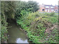
Dorcan Stream in Covingham, Swindon
Viewed looking upstream from the Bullfinch Close road bridge with the houses in Gilling Way visible to the right.
Image: © Nigel Cox
Taken: 12 Oct 2007
0.11 miles
5
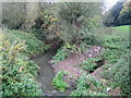
Dorcan Stream in Covingham, Swindon
Dorcan Stream is a tributary of the River Cole and is viewed here looking upstream from the footbridge to Dorcan Technology College from St Paul's Drive. This area of Swindon is now mainly residential but a glance at the 1940s OS mapping shows open fields with barely a farm building in sight.
Image: © Nigel Cox
Taken: 12 Oct 2007
0.13 miles
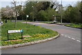
6
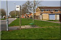
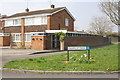
Bus stop on St Paul's Drive
There used to be a bus shelter here: now just the concrete base remains with a seat on it. See http://www.bench-marks.org.uk/bm56148
Image: © Roger Templeman
Taken: 9 Apr 2015
0.14 miles
7
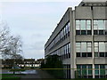
Houses in St Pauls Drive, Covingham, Swindon
The large building at right of the image is a drug manufacturer called Patheon UK Ltd. It and the houses went up in the 1960s.
Image: © Brian Robert Marshall
Taken: 7 Jan 2007
0.15 miles
8
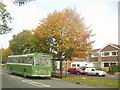
Autumn at Covingham Park
A bus stop on Kingfisher Drive at Covingham Park, as the trees begin to change colour in autumn. Many of the streets in this area have the names of birds. The Bristol RE bus is giving free trips around Swindon today.
Image: © David Roberts
Taken: Unknown
0.18 miles
9
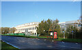
Dorcan Way, Swindon
Dorcan Way, B4006, is the major road through a large area of suburbs on the west side of Swindon.
The large building is Patheon Pharma Services.
Image: © Des Blenkinsopp
Taken: 9 Nov 2022
0.20 miles
10
Junction of Gantlettdene and St Paul's Drive
There is an OS benchmark Image on the garage wall, above the pavement of St Paul's Drive (at the junction of the garage and car port walls)
Image: © Roger Templeman
Taken: 9 Apr 2015
0.21 miles