IMAGES TAKEN NEAR TO
Lancaster Mews, SWINDON, SN3 4YF
Introduction
This page details the photographs taken nearby to Lancaster Mews, SN3 4YF by members of the Geograph project.
The Geograph project started in 2005 with the aim of publishing, organising and preserving representative images for every square kilometre of Great Britain, Ireland and the Isle of Man.

There are currently over 7.5m images from over14,400 individuals and you can help contribute to the project by visiting https://www.geograph.org.uk
Image Map (Loading...)


Getting Data...Please wait
Leaflet Map data © OpenStreetMap
Images are licensed for reuse under creativecommons.org/licenses/by-sa/2.0
Notes
- Clicking on the map will re-center to the selected point.
- The higher the marker number, the further away the image location is from the centre of the postcode.
Image Listing (10 Images Found)
Images are licensed for reuse under creativecommons.org/licenses/by-sa/2.0
Image
Details
Distance
1
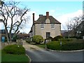
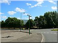
1 Lancaster Mews, South Marston, Swindon
Once a farmhouse, this is now used as an office and has been for years. It is surrounded by massive warehouses now in an area that was an aircraft factory.
Image: © Brian Robert Marshall
Taken: 6 Apr 2008
0.02 miles
2
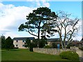
Trees and offices, South Marston Industrial Estate, Swindon
The wall in the foreground marks the boundary of the grounds of this building Image The low rise buildings behind the trees are fairly recent and are offices. The trees include an evergreen of some sort and a deciduous tree not yet in leaf.
Image: © Brian Robert Marshall
Taken: 6 Apr 2008
0.03 miles
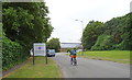
3
Entrance to Honda Factory, Viscount Way
Entrance to Honda car factory.
Image: © Vieve Forward
Taken: 26 Dec 2012
0.11 miles
4

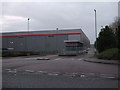
Prologis Park DC1 Swindon
This new building is one of two developed in this square by a company called Prologis. This one is to be occupied by Honda, the other building is still available...
Image: © Brian Robert Marshall
Taken: 4 Nov 2006
0.17 miles
5

Prologis Park DC2 building South Marston Swindon
This new building offers 302,000 square feet (over 28,000 square metres) should one need so much. Update: the building is now occupied by Morrison's, the large supermarket operator (April 2008).
Image: © Brian Robert Marshall
Taken: 4 Nov 2006
0.20 miles
6
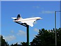
Concorde, Stirling Road, South Marston, Swindon
This part of South Marston is a business park. It was once a wartime aircraft factory and this use continued for some years after 1945. This is a quite realistic-looking model of the Concorde. For another view see http://tinyurl.com/cjd2ffr
Image: © Brian Robert Marshall
Taken: 25 Jun 2008
0.21 miles
7
Concorde, Stirling Road, South Marston, Swindon
This part of South Marston is a business park. It was once a wartime aircraft factory and this use continued for some years after 1945. Although there are no aircraft-related businesses there are aeronautical reminders to be found in road names, a model Spitfire http://www.geograph.org.uk/photo/272713 and this Concorde also seen here http://www.geograph.org.uk/photo/860713
Image: © Brian Robert Marshall
Taken: 25 Jun 2008
0.21 miles
8
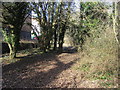
Path nearing South Marston Park
Path from Highworth Road nearing South Marston Park
Image: © Shaun Ferguson
Taken: 8 Mar 2012
0.21 miles
10

Spitfire Cafe, Hunt's Rise, South Marston Industrial Estate
The name is one of several aeronautical references on this Industrial Estate: an airfield and aircraft factory were here during the Second World War.http://www.swindonweb.com/index.asp?m=8&s=116&ss=402 Hunt's Rise is named after Hunt's Copse Farm, which housed land girls during the war.http://swindonhistory.blogspot.co.uk/2012/09/hunts-copse-farm-south-marston.html The airfield was bought by Honda, whose giant factory now occupies the space.
Image: © Vieve Forward
Taken: 26 Dec 2012
0.25 miles