IMAGES TAKEN NEAR TO
Carman Close, SWINDON, SN3 4XU
Introduction
This page details the photographs taken nearby to Carman Close, SN3 4XU by members of the Geograph project.
The Geograph project started in 2005 with the aim of publishing, organising and preserving representative images for every square kilometre of Great Britain, Ireland and the Isle of Man.

There are currently over 7.5m images from over14,400 individuals and you can help contribute to the project by visiting https://www.geograph.org.uk
Image Map
Images are licensed for reuse under creativecommons.org/licenses/by-sa/2.0
Notes
- Clicking on the map will re-center to the selected point.
- The higher the marker number, the further away the image location is from the centre of the postcode.
Image Listing (93 Images Found)
Images are licensed for reuse under creativecommons.org/licenses/by-sa/2.0
Image
Details
Distance

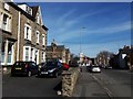
2
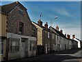
Ermin Street, Stratton St Margaret
The expansion of Swindon after the arrival of the Great Western railway turned Stratton into a suburb but this rugged terrace on Ermin Street is a survival of the old village. The gable-end of the cottage on the left is dated 1789 on a stone above the first-floor window.
Image: © Chris Brown
Taken: 21 Mar 2018
0.06 miles
3
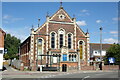
Stratton Methodist Church, Stratton St. Margaret
On Ermin Street at the junction with Swindon Road
Image: © Geographer
Taken: 14 Jul 2022
0.07 miles
4
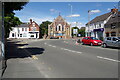
Swindon Road, Stratton St Margaret
Looking towards Stratton Methodist Church at the junction with Ermin Street
Image: © Geographer
Taken: 14 Jul 2022
0.07 miles
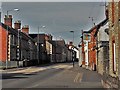
5
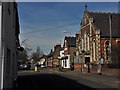
Ermin Street, Stratton St Margaret
Looking north-west along the Roman road, past Stratton Methodist church and the Swindon Road turn into the no-through section.
Image: © Chris Brown
Taken: 21 Mar 2018
0.07 miles
6
Swindon Road, Stratton St Margaret
Approaching the junction with Ermin Street.
Image: © Chris Brown
Taken: 21 Mar 2018
0.07 miles
7
Ermin Street and the Wheatsheaf, Stratton St Margaret
Image: © Chris Brown
Taken: 21 Mar 2018
0.08 miles
8

Ermin Street, Stratton St Margaret
This part of Ermin Street, between the Highworth and Swindon Roads, is closed to through traffic. Ermin Street is the Roman road from Silchester (Calleva Atrebatum) in Hampshire to Gloucester (Glevum) via Cirencester (Corinium); Stratton means the farm or settlement on the Street, or Roman road.
Image: © Chris Brown
Taken: 21 Mar 2018
0.08 miles
9
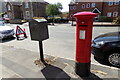
Swindon Road George VI Postbox
On Swindon Road
Postbox No. SM3 141D
Image: © Geographer
Taken: 14 Jul 2022
0.08 miles
10
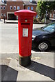
Swindon Road George VI Postbox
On Swindon Road
Postbox No. SM3 141D
Image: © Geographer
Taken: 14 Jul 2022
0.08 miles