IMAGES TAKEN NEAR TO
Highworth Road, SWINDON, SN3 4QS
Introduction
This page details the photographs taken nearby to Highworth Road, SN3 4QS by members of the Geograph project.
The Geograph project started in 2005 with the aim of publishing, organising and preserving representative images for every square kilometre of Great Britain, Ireland and the Isle of Man.

There are currently over 7.5m images from over14,400 individuals and you can help contribute to the project by visiting https://www.geograph.org.uk
Image Map
Images are licensed for reuse under creativecommons.org/licenses/by-sa/2.0
Notes
- Clicking on the map will re-center to the selected point.
- The higher the marker number, the further away the image location is from the centre of the postcode.
Image Listing (40 Images Found)
Images are licensed for reuse under creativecommons.org/licenses/by-sa/2.0
Image
Details
Distance
1
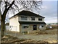
Not 13 Highworth Road, Stratton, Swindon
The house seen in this image Image just over three weeks ago was demolished recently. In a few years time folk will forget it ever existed.
Image: © Brian Robert Marshall
Taken: 19 Mar 2011
0.04 miles
2
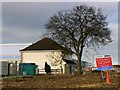
A tree and the location of the former 13 Highworth Road, Stratton, Swindon
A little over three weeks ago the scene here looked like this Image The rather attractive house that stood by the tree was demolished in a day.
Image: © Brian Robert Marshall
Taken: 19 Mar 2011
0.04 miles
3
13 Highworth Road, Stratton, Swindon
This attractive property is now empty and exposed to the gaze of anyone passing by. It was not always so http://maps.google.co.uk/?ie=UTF8&ll=51.591862,-1.746451&spn=0.001866,0.005681&t=h&z=18&layer=c&cbll=51.591766,-1.746528&panoid=KYGG8_PzJbWvCsLLEkVlrQ&cbp=12,324.56,,0,13.88 The house is due to be demolished in the next few weeks although the walnut tree at the left is safe. The reason for the house's demise is visible in the background Image The house was used yesterday by the local fire brigade for a training exercise, which is why the windows are open.
Image: © Brian Robert Marshall
Taken: 24 Feb 2011
0.04 miles
4
A tree and 13 Highworth Road, Stratton, Swindon
This substantial dwelling is now vacant and awaiting demolition. Its demise was occasioned by the development of this http://www.geograph.org.uk/photo/2282180 and associated road realignment. The tree is a walnut and will be spared.
Image: © Brian Robert Marshall
Taken: 24 Feb 2011
0.04 miles
5
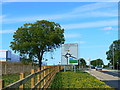
Walnut tree, Stratton, Swindon
The tree at the left now in full leaf was pictured earlier in the year Image
Image: © Brian Robert Marshall
Taken: 24 Jul 2011
0.04 miles
6
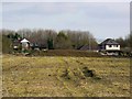
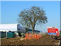
Field west of Highworth Road, Stratton, Swindon
The field is relatively small and is situated just south of this Image The property in the background fronts onto Highworth Road and is typical between-the-wars ribbon development. It looks as though the last crop in the field was maize.
Image: © Brian Robert Marshall
Taken: 24 Feb 2011
0.04 miles
7

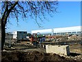
Part of the B&Q Distribution Centre, Stratton, Swindon
Most of the very large structure can be seen here Image The graduated façade works best with white cloud.
Image: © Brian Robert Marshall
Taken: 24 Feb 2011
0.05 miles
8
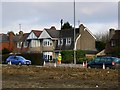
Surveying, Highworth Road, Stratton, Swindon (2 of 2)
This is a companion image to this one Image Both surveyors appear to be on the phone to each other. The houses beyond date to the years before the second world war and are typical of the ribbon development of that era.
Image: © Brian Robert Marshall
Taken: 24 Feb 2011
0.06 miles
9
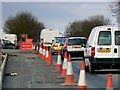
Traffic, A361, Stratton, Swindon
White vans, a Volvo and a police Mondeo make their way through the roadworks near the new B&Q distribution centre seen here Image
Image: © Brian Robert Marshall
Taken: 24 Feb 2011
0.08 miles
10
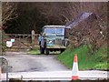
Landrover, Highworth Road, Swindon
A well-used Landie is parked on what was once a slip road onto the A419. It can be seen in a wider context here Image
Image: © Brian Robert Marshall
Taken: 24 Feb 2011
0.08 miles