IMAGES TAKEN NEAR TO
Ermin Street, SWINDON, SN3 4NN
Introduction
This page details the photographs taken nearby to Ermin Street, SN3 4NN by members of the Geograph project.
The Geograph project started in 2005 with the aim of publishing, organising and preserving representative images for every square kilometre of Great Britain, Ireland and the Isle of Man.

There are currently over 7.5m images from over14,400 individuals and you can help contribute to the project by visiting https://www.geograph.org.uk
Image Map (Loading...)


Getting Data...Please wait
Leaflet Map data © OpenStreetMap
Images are licensed for reuse under creativecommons.org/licenses/by-sa/2.0
Notes
- Clicking on the map will re-center to the selected point.
- The higher the marker number, the further away the image location is from the centre of the postcode.
Image Listing (37 Images Found)
Images are licensed for reuse under creativecommons.org/licenses/by-sa/2.0
Image
Details
Distance
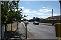
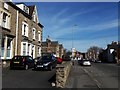
1
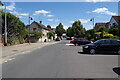
Ermin Street, Stratton St Margaret
Looking towards the junction with Swindon Road
Image: © Geographer
Taken: 14 Jul 2022
0.02 miles
3
Ermin Street, Stratton St Margaret
At the junction with the B4006 Hobley Drive, B4006 Highworth Road & B4006 Ermin Street
Image: © Geographer
Taken: 14 Jul 2022
0.05 miles
4
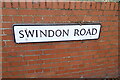
Swindon Road sign
On Swindon Road at the junction with Ermin Street
Image: © Geographer
Taken: 14 Jul 2022
0.05 miles
5
B4006 Hobley Drive, Stratton St. Margaret
Looking towards Aldi Superstore at the junction with the B4006 Ermin Street, B4006 Highworth Road & B4006 Ermin Street
Image: © Geographer
Taken: 14 Jul 2022
0.05 miles
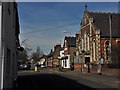
6

Ermin Street, Stratton St Margaret
This part of Ermin Street, between the Highworth and Swindon Roads, is closed to through traffic. Ermin Street is the Roman road from Silchester (Calleva Atrebatum) in Hampshire to Gloucester (Glevum) via Cirencester (Corinium); Stratton means the farm or settlement on the Street, or Roman road.
Image: © Chris Brown
Taken: 21 Mar 2018
0.05 miles
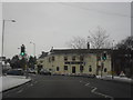
8
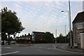
Roundabout on Ermin Street, Stratton St Margaret
For reasons only known to Swindon council the road is closed here and traffic diverted round a very long block if they wish to continue on Ermin Street. Only buses are now allowed to use it as it was before.
Image: © David Howard
Taken: 9 Sep 2018
0.06 miles
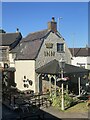
9
Ermin Street, Stratton St Margaret
Looking north-west along the Roman road, past Stratton Methodist church and the Swindon Road turn into the no-through section.
Image: © Chris Brown
Taken: 21 Mar 2018
0.06 miles
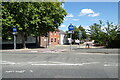
10
Swindon Road, Stratton St Margaret
Approaching the junction with Ermin Street.
Image: © Chris Brown
Taken: 21 Mar 2018
0.06 miles