IMAGES TAKEN NEAR TO
Grange Drive, SWINDON, SN3 4JX
Introduction
This page details the photographs taken nearby to Grange Drive, SN3 4JX by members of the Geograph project.
The Geograph project started in 2005 with the aim of publishing, organising and preserving representative images for every square kilometre of Great Britain, Ireland and the Isle of Man.

There are currently over 7.5m images from over14,400 individuals and you can help contribute to the project by visiting https://www.geograph.org.uk
Image Map
Images are licensed for reuse under creativecommons.org/licenses/by-sa/2.0
Notes
- Clicking on the map will re-center to the selected point.
- The higher the marker number, the further away the image location is from the centre of the postcode.
Image Listing (7 Images Found)
Images are licensed for reuse under creativecommons.org/licenses/by-sa/2.0
Image
Details
Distance
1
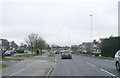
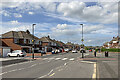
Lower Stratton: along Grange Drive
A view towards Swindon from the Stratton shops bus stop.
Image: © John Sutton
Taken: 21 May 2022
0.02 miles
2
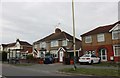
Lower Stratton: Grange Drive
Looking north towards Grange Leisure and Community Centre and the junior school from the Stratton shops bus stop. This is the route of the No 7 bus which connects Swindon and Highworth.
Image: © John Sutton
Taken: 21 May 2022
0.06 miles
3
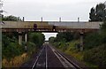
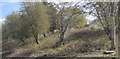
Footbridge over the railway in Lower Stratton
Image: © Steve Daniels
Taken: 2 Sep 2009
0.14 miles
4
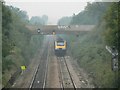
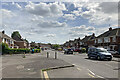
Footbridge over Swindon to Paddington railway
This footbridge is one of four bridges over the line within one kilometre. The train is Paddington-bound on the 'up' line.
NOTE. This image has a detailed ‘shared description’ which you won’t see by viewing this image on a slideshow. To read it click on the image.
Image: © Brian Robert Marshall
Taken: 16 Sep 2006
0.14 miles