IMAGES TAKEN NEAR TO
Carver Close, SWINDON, SN3 4GJ
Introduction
This page details the photographs taken nearby to Carver Close, SN3 4GJ by members of the Geograph project.
The Geograph project started in 2005 with the aim of publishing, organising and preserving representative images for every square kilometre of Great Britain, Ireland and the Isle of Man.

There are currently over 7.5m images from over14,400 individuals and you can help contribute to the project by visiting https://www.geograph.org.uk
Image Map
Images are licensed for reuse under creativecommons.org/licenses/by-sa/2.0
Notes
- Clicking on the map will re-center to the selected point.
- The higher the marker number, the further away the image location is from the centre of the postcode.
Image Listing (18 Images Found)
Images are licensed for reuse under creativecommons.org/licenses/by-sa/2.0
Image
Details
Distance
1
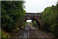
Roman Road Bridge, Ermin Street, Stratton St Margaret
Roman Road Bridge (MLN 17508) is a Grade II Listed skew road overbridge with a single semi-circular arch, constructed c.1839-40 to carry Ermin Street across a Great Western Railway cutting (see also Image]). It is well worth reading the listing text http://www.britishlistedbuildings.co.uk/en-1409198-roman-road-bridge-mln17508-stratton-st- to set this bridge in the context of the history of the Great Western line from London to Bristol and of Isambard Kingdom Brunel’s involvement in its design.
Roman Road Bridge is the first stone bridge encountered when travelling west from London. It carries a road on the alignment of Ermin Street, the major Roman road from Gloucester (Glevum) to Silchester (Calleva Atrebatum). The form of the bridge is unique on the line, with a semi-circular arch springing almost from rail level built on a skew angle of 25 degrees with quarry-faced elevations of Swindon Portland stone and originally a classical tablet motif in the centre of each parapet. It is possible that Brunel took his inspiration for the design and its classical vocabulary from the Roman origins of the road which it carried (the Romans invented the arch, and semi-circular arches are characteristic of their viaducts and bridges).
This stretch of the line was never quadrupled and so the bridge has not been extended. However, in the 20th century the parapets, soffits and some patches were refaced in purple engineering brick. A number of tie rods were also inserted.
The importance of this bridge can be gauged by the statement in the listing that “were the original design to survive completely, a higher grade would be warranted”.
When Roman Road Bridge was constructed it was in open countryside. Today the setting has been engulfed by the suburban spread of Swindon New Town.
Image: © Vieve Forward
Taken: 22 Mar 2013
0.07 miles
5
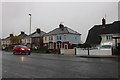
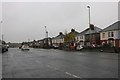
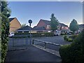
Houses on Oxford Road, Stratton St Margaret
Image: © David Howard
Taken: 26 Oct 2019
0.17 miles
6
Footbridge over the railway in Lower Stratton
Image: © Steve Daniels
Taken: 2 Sep 2009
0.19 miles
7
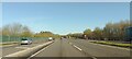
A419 northbound
Travelling northbound on the A419. Traffic is merging ahead having come from a slip road from White Hart.
Image: © Oscar Taylor
Taken: 7 Apr 2023
0.20 miles
8
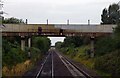
A419 at the railway bridge
The Swindon-Cirencester road crosses the Great Western Railway's main line at this point.
Image: © J Whatley
Taken: 22 Sep 2010
0.22 miles
10
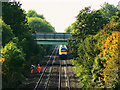
HST 125 en route to London Paddington, South Marston, Swindon
A pair of lineside workers are about to be passed by the oncoming High Speed Train. It is travelling relatively slowly having only just left Swindon Station. The bridge in the background carries the A419 dual carriageway over the railway. One of the track workers is waving, not at me but at another HST on its way west Image
Note. This image has a detailed ‘shared description’ which you won’t see by viewing this image on a slideshow. To read it click on the image.
Image: © Brian Robert Marshall
Taken: 7 Oct 2010
0.23 miles