IMAGES TAKEN NEAR TO
Trajan Road, SWINDON, SN3 4BW
Introduction
This page details the photographs taken nearby to Trajan Road, SN3 4BW by members of the Geograph project.
The Geograph project started in 2005 with the aim of publishing, organising and preserving representative images for every square kilometre of Great Britain, Ireland and the Isle of Man.

There are currently over 7.5m images from over14,400 individuals and you can help contribute to the project by visiting https://www.geograph.org.uk
Image Map (Loading...)


Getting Data...Please wait
Leaflet Map data © OpenStreetMap
Images are licensed for reuse under creativecommons.org/licenses/by-sa/2.0
Notes
- Clicking on the map will re-center to the selected point.
- The higher the marker number, the further away the image location is from the centre of the postcode.
Image Listing (15 Images Found)
Images are licensed for reuse under creativecommons.org/licenses/by-sa/2.0
Image
Details
Distance
1

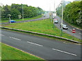
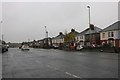
View from Merlin Way to Trajan Road, Stratton, Swindon
In the foreground is Merlin Way seen in this image Image Trajan Road is one of several roads and closes forming part of a post-war private housing development where the names are taken from the days of the Roman Empire. Other names include Hadrian, Cunetio, Verulam, Forum and Centurion. Archaeological evidence of the Romano-British era has been found in the locality.
Image: © Brian Robert Marshall
Taken: 5 Mar 2010
0.09 miles
2
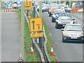
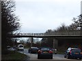
A420 adjacent to A419, Swindon
This section of the A420 affords access to the northbound A419 and to the residential areas of east Swindon. Roadworks are being carried out in the far distance. The image was obtained from a footbridge that passes over the roundabout in the foreground and under the A419 thus enabling pedestrians to walk safely through this fairly complex road junction. It was paid for by the developers of the Gablecross business park that includes Sainsbury's and Toys R Us. The blue smudge in the top right corner of the image is smoke.
Image: © Brian Robert Marshall
Taken: 24 Apr 2007
0.13 miles
3

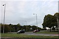
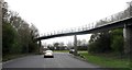
Merlin Way, Stratton, Swindon
This short but important length of dual carriageway is part of the complicated junction of the A419 and A420 main roads. The former connects the M4 and M5 motorways and the latter runs between Oxford to the east and Swindon. Drivers heading north from the M4, south of here wanting to travel into Swindon or turn east on the A420 would use this stretch as would drivers intending to go north towards the M5 arriving here from the east or west.
Image: © Brian Robert Marshall
Taken: 5 Mar 2010
0.15 miles
4
Bi-lingual road sign, A420, Swindon
This sign is in both English and Welsh. The contractors, visible in the background, possibly have just finished a project in Wales before starting this one. The image was obtained using a lot of zoom from a footbridge. More information in this image Image
Image: © Brian Robert Marshall
Taken: 24 Apr 2007
0.15 miles
5
Roundabout on Merlin Way entering Swindon
Image: © David Howard
Taken: 9 Sep 2018
0.17 miles
6
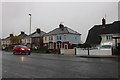
Houses on Oxford Road, Stratton St Margaret
Image: © David Howard
Taken: 26 Oct 2019
0.19 miles
8

Flyovers above the White Hart roundabout, Stratton St Margaret
Image: © David Howard
Taken: 9 Sep 2018
0.19 miles
9
The raised pedestrian walkway through A420 roundabout
There is a long raised walkway through the complex roundabout under the A419. A view from the walkway towards the A420 is at Image
Image: © David Smith
Taken: 28 Dec 2011
0.20 miles
10
Pedestrian Walkway over the A420 roundabout
Image: © Anthony Parkes
Taken: 5 Apr 2014
0.20 miles